Worcester geodata
Worcester (New York) is a populated place; located in United States in America/New_York (GMT-4) time zone. With population of 1,113 people, there are 15605 cities with bigger population in this country. Compared to other cities in United States, 80.5% of cities are located further ↓South; 87.9% of cities are located further ←West and 84.1% of cities have lower elevation than Worcester. Note1


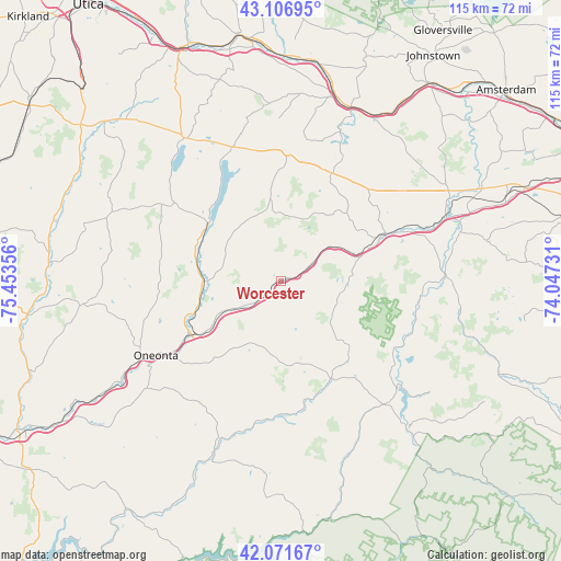
Worcester GPS coordinates[2]
42° 35' 29.256" North, 74° 45' 1.548" West
| Map corner | latitude | longitude |
|---|---|---|
| Upper-left | 43.10695°, | -75.45356° |
| Center: | 42.59146°, | -74.75043° |
| Lower-right: | 42.07167°, | -74.04731° |
| Map W x H: | 115.1×115.1 km | = 71.5×71.5mi |
| max Lat: | 71.29058° ⇑19.5% North |
| Worcester: | 42.59146° |
| min Lat: | ⇓80.5% South 19.06759° |
| min Long | Worcester | max Long |
| -171.73463° | -74.75043° | -66.98998° |
| W 87.9%⇐ | ⇒12.1% E |
Elevation
Elevation of Worcester is 407 m = 1335 ft, and this is 112.2 m = 368 ft above average elevation for this country.
| Max E: |
3189 m = 10463 ft | 15.9% |
| Worcester | 407 m 1335 ft | |
| Avg. | 294.8 m = 967 ft | |
Min E: |
-60 m = -197 ft | 84.1% |
See also: United States elevation on elevation.city.
Geographical zone
Worcester is located in North temperate zone (between Tropic of Cancer and the Arctic Circle). Distance of this Northern Tropic circle is 2129.8 km =1323.4 mi to South.| Distance of | km | miles | from Worcester |
|---|---|---|---|
| North Pole | 5271.3 | 3275.4 | to North |
| Arctic Circle | 2665.4 | 1656.2 | to North |
| Tropic Cancer | 2129.8 | 1323.4 | to South |
| Equator | 4735.7 | 2942.6 | to South |


Nearby cities:
15 places around Worcester: (largest is in red/bold)
• Central Bridge
36.2 km =22.5 mi,  68°
68°
• Cherry Valley
22.7 km =14.1 mi,  359°
359°
• Cobleskill
23.7 km =14.7 mi, 66°
• Cooperstown
18.7 km =11.6 mi,  310°
310°
• Hartwick
25.6 km =15.9 mi,  287°
287°
• Middleburgh
34.2 km =21.3 mi,  88°
88°
• Oneonta
29.9 km =18.6 mi,  239°
239°
• Richfield Springs
34.9 km =21.7 mi,  326°
326°
• Richmondville
16 km =9.9 mi, 72°
• Schenevus
7.5 km =4.7 mi,  230°
230°
• Schoharie
37 km =23 mi,  77°
77°
• Sharon Springs
25.2 km =15.7 mi,  25°
25°
• Springfield
28.5 km =17.7 mi,  342°
342°
• Stamford
23.3 km =14.5 mi,  151°
151°
• West End
31.3 km =19.4 mi, 244°
Sources, notices
• [Note1] Compared only with cities in United States existing in our database
• [Src1] Map data: © OpenStreetMap contributors (CC-BY-SA)
• [Src2] Other city data from geonames.org with taken over terms of usage.
• [Src3] Geographical zone / Annual Mean Temperature by Robert A. Rohde @ Wikipedia
