Corona geodata
Corona (New York) is a populated place; located in United States in America/New_York (GMT-4) time zone. With population of 109,698 people, there are 308 cities with bigger population in this country. Compared to other cities in United States, 62.3% of cities are located further ↓South; 91.4% of cities are located further ←West and 92.1% of cities have higher elevation than Corona. Note1


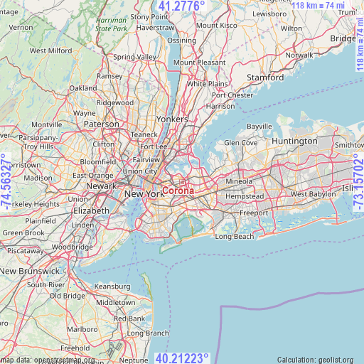
Corona GPS coordinates[2]
40° 44' 49.38" North, 73° 51' 36.504" West
| Map corner | latitude | longitude |
|---|---|---|
| Upper-left | 41.2776°, | -74.56327° |
| Center: | 40.74705°, | -73.86014° |
| Lower-right: | 40.21223°, | -73.15702° |
| Map W x H: | 118.5×118.5 km | = 73.6×73.6mi |
| max Lat: | 71.29058° ⇑37.7% North |
| Corona: | 40.74705° |
| min Lat: | ⇓62.3% South 19.06759° |
| min Long | Corona | max Long |
| -171.73463° | -73.86014° | -66.98998° |
| W 91.4%⇐ | ⇒8.6% E |
Elevation
Elevation of Corona is 12 m = 39 ft, and this is 282.8 m = 928 ft below average elevation for this country.
| Max E: |
3189 m = 10463 ft | 92.1% |
| Avg. | 294.8 m = 967 ft | |
| Corona | 12 m = 39 ft | |
Min E: |
-60 m = -197 ft | 7.9% |
See also: Corona elevation on elevation.city.
Geographical zone
Corona is located in North temperate zone (between Tropic of Cancer and the Arctic Circle). Distance of this Northern Tropic circle is 1924.7 km =1196 mi to South.| Distance of | km | miles | from Corona |
|---|---|---|---|
| North Pole | 5476.4 | 3402.9 | to North |
| Arctic Circle | 2870.5 | 1783.6 | to North |
| Tropic Cancer | 1924.7 | 1196 | to South |
| Equator | 4530.6 | 2815.2 | to South |


Nearby cities:
15 places around Corona: (largest is in red/bold)
• Briarwood
5.6 km =3.5 mi,  137°
137°
• College Point
4.7 km =2.9 mi,  14°
14°
• East Elmhurst
1.6 km =1 mi,  345°
345°
• Elmhurst
1.9 km =1.2 mi,  231°
231°
• Forest Hills
3.5 km =2.2 mi,  166°
166°
• Fresh Meadows
5.8 km =3.6 mi,  103°
103°
• Glendale
5.5 km =3.4 mi,  203°
203°
• Jackson Heights
2.3 km =1.4 mi,  294°
294°
• Kew Gardens
4.4 km =2.7 mi,  146°
146°
• Kew Gardens Hills
3.6 km =2.2 mi,  121°
121°
• Maspeth
5.2 km =3.2 mi,  239°
239°
• Middle Village
3.8 km =2.4 mi,  207°
207°
• Rego Park
2.4 km =1.5 mi,  164°
164°
• Steinway
4.8 km =3 mi,  309°
309°
• Woodside
3.8 km =2.4 mi,  267°
267°
Sources, notices
• [Note1] Compared only with cities in United States existing in our database
• [Src1] Map data: © OpenStreetMap contributors (CC-BY-SA)
• [Src2] Other city data from geonames.org with taken over terms of usage.
• [Src3] Geographical zone / Annual Mean Temperature by Robert A. Rohde @ Wikipedia
