Elmhurst geodata
Elmhurst (New York) is a populated place; located in United States in America/New_York (GMT-4) time zone. With population of 113,364 people, there are 282 cities with bigger population in this country. Compared to other cities in United States, 62.1% of cities are located further ↓South; 91.3% of cities are located further ←West and 95.7% of cities have higher elevation than Elmhurst. Note1


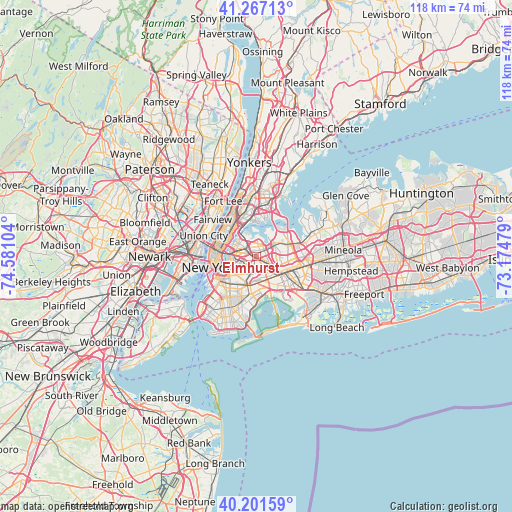
Elmhurst GPS coordinates[2]
40° 44' 11.364" North, 73° 52' 40.476" West
| Map corner | latitude | longitude |
|---|---|---|
| Upper-left | 41.26713°, | -74.58104° |
| Center: | 40.73649°, | -73.87791° |
| Lower-right: | 40.20159°, | -73.17479° |
| Map W x H: | 118.5×118.5 km | = 73.6×73.6mi |
| max Lat: | 71.29058° ⇑37.9% North |
| Elmhurst: | 40.73649° |
| min Lat: | ⇓62.1% South 19.06759° |
| min Long | Elmhurst | max Long |
| -171.73463° | -73.87791° | -66.98998° |
| W 91.3%⇐ | ⇒8.7% E |
Elevation
Elevation of Elmhurst is 8 m = 26 ft, and this is 286.8 m = 941 ft below average elevation for this country.
| Max E: |
3189 m = 10463 ft | 95.7% |
| Avg. | 294.8 m = 967 ft | |
| Elmhurst | 8 m = 26 ft | |
Min E: |
-60 m = -197 ft | 4.3% |
See also: Elmhurst elevation on elevation.city.
Geographical zone
Elmhurst is located in North temperate zone (between Tropic of Cancer and the Arctic Circle). Distance of this Northern Tropic circle is 1923.6 km =1195.3 mi to South.| Distance of | km | miles | from Elmhurst |
|---|---|---|---|
| North Pole | 5477.6 | 3403.6 | to North |
| Arctic Circle | 2871.7 | 1784.4 | to North |
| Tropic Cancer | 1923.6 | 1195.3 | to South |
| Equator | 4529.5 | 2814.5 | to South |


Nearby cities:
15 places around Elmhurst: (largest is in red/bold)
• Corona
1.9 km =1.2 mi,  51°
51°
• East Elmhurst
3 km =1.9 mi,  21°
21°
• Forest Hills
3.2 km =2 mi,  133°
133°
• Glendale
4 km =2.5 mi,  190°
190°
• Jackson Heights
2.2 km =1.4 mi,  343°
343°
• Kew Gardens
4.7 km =2.9 mi,  121°
121°
• Kew Gardens Hills
4.6 km =2.9 mi,  98°
98°
• Maspeth
3.3 km =2.1 mi,  243°
243°
• Middle Village
2.2 km =1.4 mi, 187°
• Rego Park
2.4 km =1.5 mi, 117°
• Ridgewood
4.7 km =2.9 mi,  210°
210°
• Steinway
4.8 km =3 mi,  332°
332°
• Sunnyside
4.9 km =3 mi,  274°
274°
• Woodhaven
5.5 km =3.4 mi,  162°
162°
• Woodside
2.5 km =1.6 mi,  293°
293°
Sources, notices
• [Note1] Compared only with cities in United States existing in our database
• [Src1] Map data: © OpenStreetMap contributors (CC-BY-SA)
• [Src2] Other city data from geonames.org with taken over terms of usage.
• [Src3] Geographical zone / Annual Mean Temperature by Robert A. Rohde @ Wikipedia
