Maspeth geodata
Maspeth (New York) is a populated place; located in United States in America/New_York (GMT-4) time zone. With population of 48,325 people, there are 994 cities with bigger population in this country. Compared to other cities in United States, 61.9% of cities are located further ↓South; 91.1% of cities are located further ←West and 93.9% of cities have higher elevation than Maspeth. Note1


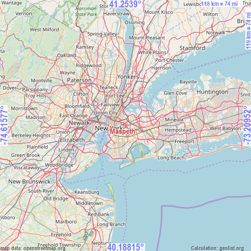
Maspeth GPS coordinates[2]
40° 43' 23.376" North, 73° 54' 45.504" West
| Map corner | latitude | longitude |
|---|---|---|
| Upper-left | 41.2539°, | -74.61577° |
| Center: | 40.72316°, | -73.91264° |
| Lower-right: | 40.18815°, | -73.20952° |
| Map W x H: | 118.5×118.5 km | = 73.6×73.6mi |
| max Lat: | 71.29058° ⇑38.1% North |
| Maspeth: | 40.72316° |
| min Lat: | ⇓61.9% South 19.06759° |
| min Long | Maspeth | max Long |
| -171.73463° | -73.91264° | -66.98998° |
| W 91.1%⇐ | ⇒8.9% E |
Elevation
Elevation of Maspeth is 10 m = 33 ft, and this is 284.8 m = 934 ft below average elevation for this country.
| Max E: |
3189 m = 10463 ft | 93.9% |
| Avg. | 294.8 m = 967 ft | |
| Maspeth | 10 m = 33 ft | |
Min E: |
-60 m = -197 ft | 6.1% |
See also: Maspeth elevation on elevation.city.
Geographical zone
Maspeth is located in North temperate zone (between Tropic of Cancer and the Arctic Circle). Distance of this Northern Tropic circle is 1922.1 km =1194.3 mi to South.| Distance of | km | miles | from Maspeth |
|---|---|---|---|
| North Pole | 5479.1 | 3404.6 | to North |
| Arctic Circle | 2873.2 | 1785.3 | to North |
| Tropic Cancer | 1922.1 | 1194.3 | to South |
| Equator | 4528 | 2813.6 | to South |


Nearby cities:
15 places around Maspeth: (largest is in red/bold)
• Bushwick
3.3 km =2.1 mi,  189°
189°
• Corona
5.2 km =3.2 mi,  59°
59°
• Cypress Hills
5.4 km =3.4 mi,  160°
160°
• Elmhurst
3.3 km =2.1 mi, 63°
• Forest Hills
5.3 km =3.3 mi,  98°
98°
• Glendale
3.2 km =2 mi,  137°
137°
• Greenpoint
3.2 km =2 mi,  271°
271°
• Jackson Heights
4.3 km =2.7 mi,  32°
32°
• Long Island City
3.9 km =2.4 mi,  308°
308°
• Middle Village
2.7 km =1.7 mi,  105°
105°
• Rego Park
5.1 km =3.2 mi,  85°
85°
• Ridgewood
2.6 km =1.6 mi,  167°
167°
• Sunnyside
2.7 km =1.7 mi, 313°
• Williamsburg
3.6 km =2.2 mi,  253°
253°
• Woodside
2.5 km =1.6 mi,  13°
13°
Sources, notices
• [Note1] Compared only with cities in United States existing in our database
• [Src1] Map data: © OpenStreetMap contributors (CC-BY-SA)
• [Src2] Other city data from geonames.org with taken over terms of usage.
• [Src3] Geographical zone / Annual Mean Temperature by Robert A. Rohde @ Wikipedia
