Parkchester geodata
Parkchester (New York) is a populated place; located in United States in America/New_York (GMT-4) time zone. With population of 65,876 people, there are 648 cities with bigger population in this country. Compared to other cities in United States, 63.8% of cities are located further ↓South; 91.4% of cities are located further ←West and 87.4% of cities have higher elevation than Parkchester. Note1


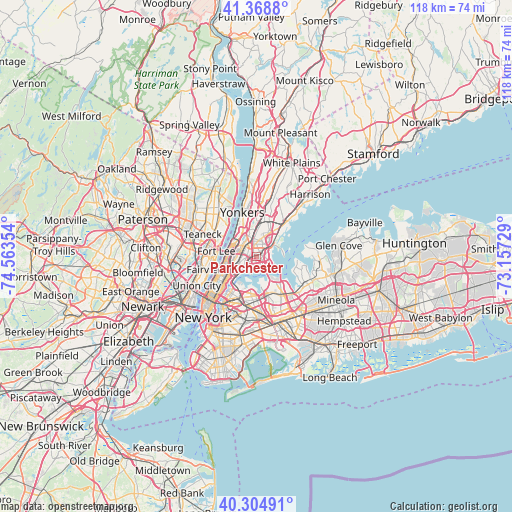
Parkchester GPS coordinates[2]
40° 50' 20.364" North, 73° 51' 37.476" West
| Map corner | latitude | longitude |
|---|---|---|
| Upper-left | 41.3688°, | -74.56354° |
| Center: | 40.83899°, | -73.86041° |
| Lower-right: | 40.30491°, | -73.15729° |
| Map W x H: | 118.3×118.3 km | = 73.5×73.5mi |
| max Lat: | 71.29058° ⇑36.2% North |
| Parkchester: | 40.83899° |
| min Lat: | ⇓63.8% South 19.06759° |
| min Long | Parkchester | max Long |
| -171.73463° | -73.86041° | -66.98998° |
| W 91.4%⇐ | ⇒8.6% E |
Elevation
Elevation of Parkchester is 22 m = 72 ft, and this is 272.8 m = 895 ft below average elevation for this country.
| Max E: |
3189 m = 10463 ft | 87.4% |
| Avg. | 294.8 m = 967 ft | |
| Parkchester | 22 m = 72 ft | |
Min E: |
-60 m = -197 ft | 12.6% |
See also: Parkchester elevation on elevation.city.
Geographical zone
Parkchester is located in North temperate zone (between Tropic of Cancer and the Arctic Circle). Distance of this Northern Tropic circle is 1935 km =1202.4 mi to South.| Distance of | km | miles | from Parkchester |
|---|---|---|---|
| North Pole | 5466.2 | 3396.5 | to North |
| Arctic Circle | 2860.3 | 1777.3 | to North |
| Tropic Cancer | 1935 | 1202.4 | to South |
| Equator | 4540.9 | 2821.6 | to South |


Nearby cities:
15 places around Parkchester: (largest is in red/bold)
• Baychester
3.9 km =2.4 mi,  30°
30°
• East Tremont
2.7 km =1.7 mi,  285°
285°
• Fordham
3.9 km =2.4 mi,  305°
305°
• Hunts Point
3.5 km =2.2 mi,  214°
214°
• Melrose
4.5 km =2.8 mi,  249°
249°
• Morris Heights
5.1 km =3.2 mi,  283°
283°
• Morris Park
1.6 km =1 mi,  21°
21°
• Morrisania
4 km =2.5 mi, 254°
• The Bronx
1.3 km =0.8 mi,  337°
337°
• Throgs Neck
3.9 km =2.4 mi,  117°
117°
• Tremont
4 km =2.5 mi, 287°
• Unionport
1.6 km =1 mi,  146°
146°
• University Heights
4.7 km =2.9 mi,  299°
299°
• Van Nest
1.1 km =0.7 mi,  345°
345°
• West Farms
1.5 km =0.9 mi,  273°
273°
Sources, notices
• [Note1] Compared only with cities in United States existing in our database
• [Src1] Map data: © OpenStreetMap contributors (CC-BY-SA)
• [Src2] Other city data from geonames.org with taken over terms of usage.
• [Src3] Geographical zone / Annual Mean Temperature by Robert A. Rohde @ Wikipedia
