Hamburg geodata
Hamburg (New York) is a populated place; located in United States in America/New_York (GMT-4) time zone. With population of 9,576 people, there are 4597 cities with bigger population in this country. Compared to other cities in United States, 81.4% of cities are located further ↓South; 76.2% of cities are located further ←West and 62.8% of cities have lower elevation than Hamburg. Note1


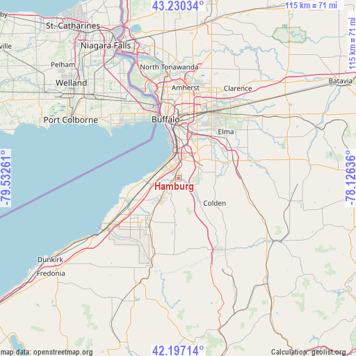
Hamburg GPS coordinates[2]
42° 42' 57.204" North, 78° 49' 46.128" West
| Map corner | latitude | longitude |
|---|---|---|
| Upper-left | 43.23034°, | -79.53261° |
| Center: | 42.71589°, | -78.82948° |
| Lower-right: | 42.19714°, | -78.12636° |
| Map W x H: | 114.9×114.9 km | = 71.4×71.4mi |
| max Lat: | 71.29058° ⇑18.6% North |
| Hamburg: | 42.71589° |
| min Lat: | ⇓81.4% South 19.06759° |
| min Long | Hamburg | max Long |
| -171.73463° | -78.82948° | -66.98998° |
| W 76.2%⇐ | ⇒23.8% E |
Elevation
Elevation of Hamburg is 252 m = 827 ft, and this is 42.8 m = 140 ft below average elevation for this country.
| Max E: |
3189 m = 10463 ft | 37.2% |
| Avg. | 294.8 m = 967 ft | |
| Hamburg | 252 m = 827 ft | |
Min E: |
-60 m = -197 ft | 62.8% |
See also: United States elevation on elevation.city.
Geographical zone
Hamburg is located in North temperate zone (between Tropic of Cancer and the Arctic Circle). Distance of this Northern Tropic circle is 2143.6 km =1332 mi to South.| Distance of | km | miles | from Hamburg |
|---|---|---|---|
| North Pole | 5257.5 | 3266.9 | to North |
| Arctic Circle | 2651.6 | 1647.6 | to North |
| Tropic Cancer | 2143.6 | 1332 | to South |
| Equator | 4749.6 | 2951.3 | to South |


Nearby cities:
15 places around Hamburg: (largest is in red/bold)
• Angola
18.4 km =11.4 mi,  242°
242°
• Angola on the Lake
19.2 km =11.9 mi,  249°
249°
• Billington Heights
18.2 km =11.3 mi,  65°
65°
• Blasdell
9.1 km =5.7 mi,  3°
3°
• Boston
12.2 km =7.6 mi,  142°
142°
• Buffalo
19.4 km =12.1 mi,  348°
348°
• East Aurora
18.6 km =11.6 mi, 71°
• Eden
9 km =5.6 mi,  217°
217°
• Lackawanna
12.2 km =7.6 mi, 2°
• North Boston
5.5 km =3.4 mi,  127°
127°
• North Collins
16.2 km =10.1 mi,  214°
214°
• Orchard Park
9 km =5.6 mi,  50°
50°
• Sloan
19.9 km =12.4 mi,  8°
8°
• Wanakah
6.9 km =4.3 mi,  299°
299°
• West Seneca
15.1 km =9.4 mi, 9°
Sources, notices
• [Note1] Compared only with cities in United States existing in our database
• [Src1] Map data: © OpenStreetMap contributors (CC-BY-SA)
• [Src2] Other city data from geonames.org with taken over terms of usage.
• [Src3] Geographical zone / Annual Mean Temperature by Robert A. Rohde @ Wikipedia
