Sloan geodata
Sloan (New York) is a populated place; located in United States in America/New_York (GMT-4) time zone. With population of 3,601 people, there are 8717 cities with bigger population in this country. Compared to other cities in United States, 82.5% of cities are located further ↓South; 76.3% of cities are located further ←West and 52.8% of cities have higher elevation than Sloan. Note1


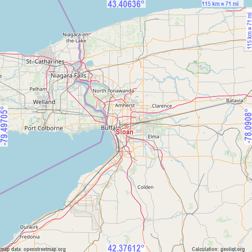
Sloan GPS coordinates[2]
42° 53' 36.204" North, 78° 47' 38.112" West
| Map corner | latitude | longitude |
|---|---|---|
| Upper-left | 43.40636°, | -79.49705° |
| Center: | 42.89339°, | -78.79392° |
| Lower-right: | 42.37612°, | -78.0908° |
| Map W x H: | 114.6×114.6 km | = 71.2×71.2mi |
| max Lat: | 71.29058° ⇑17.5% North |
| Sloan: | 42.89339° |
| min Lat: | ⇓82.5% South 19.06759° |
| min Long | Sloan | max Long |
| -171.73463° | -78.79392° | -66.98998° |
| W 76.3%⇐ | ⇒23.7% E |
Elevation
Elevation of Sloan is 188 m = 617 ft, and this is 106.8 m = 350 ft below average elevation for this country.
| Max E: |
3189 m = 10463 ft | 52.8% |
| Avg. | 294.8 m = 967 ft | |
| Sloan | 188 m = 617 ft | |
Min E: |
-60 m = -197 ft | 47.2% |
See also: United States elevation on elevation.city.
Geographical zone
Sloan is located in North temperate zone (between Tropic of Cancer and the Arctic Circle). Distance of this Northern Tropic circle is 2163.4 km =1344.3 mi to South.| Distance of | km | miles | from Sloan |
|---|---|---|---|
| North Pole | 5237.8 | 3254.6 | to North |
| Arctic Circle | 2631.9 | 1635.4 | to North |
| Tropic Cancer | 2163.4 | 1344.3 | to South |
| Equator | 4769.3 | 2963.5 | to South |


Nearby cities:
15 places around Sloan: (largest is in red/bold)
• Amherst
9.5 km =5.9 mi,  357°
357°
• Blasdell
11 km =6.8 mi,  192°
192°
• Buffalo
6.9 km =4.3 mi,  263°
263°
• Cheektowaga
3.4 km =2.1 mi,  70°
70°
• Depew
8.4 km =5.2 mi,  81°
81°
• Eggertsville
7.8 km =4.8 mi,  354°
354°
• Elma Center
14.7 km =9.1 mi,  118°
118°
• Harris Hill
12.4 km =7.7 mi,  50°
50°
• Kenmore
10.2 km =6.3 mi,  322°
322°
• Lackawanna
7.9 km =4.9 mi,  197°
197°
• Lancaster
10.1 km =6.3 mi,  85°
85°
• Orchard Park
14.6 km =9.1 mi,  163°
163°
• Tonawanda
15.8 km =9.8 mi,  333°
333°
• West Seneca
4.8 km =3 mi, 185°
• Williamsville
9.1 km =5.7 mi,  30°
30°
Sources, notices
• [Note1] Compared only with cities in United States existing in our database
• [Src1] Map data: © OpenStreetMap contributors (CC-BY-SA)
• [Src2] Other city data from geonames.org with taken over terms of usage.
• [Src3] Geographical zone / Annual Mean Temperature by Robert A. Rohde @ Wikipedia
