Buffalo geodata
Buffalo (New York) is a seat of a second-order administrative division; located in United States in America/New_York (GMT-4) time zone. With population of 258,071 people, there are 86 cities with bigger population in this country. Compared to other cities in United States, 82.4% of cities are located further ↓South; 76.1% of cities are located further ←West and 51.9% of cities have higher elevation than Buffalo. Note1


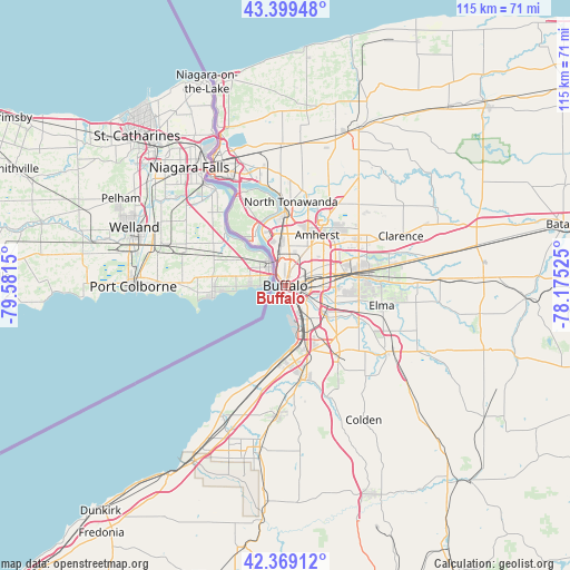
Buffalo GPS coordinates[2]
42° 53' 11.22" North, 78° 52' 42.132" West
| Map corner | latitude | longitude |
|---|---|---|
| Upper-left | 43.39948°, | -79.5815° |
| Center: | 42.88645°, | -78.87837° |
| Lower-right: | 42.36912°, | -78.17525° |
| Map W x H: | 114.6×114.6 km | = 71.2×71.2mi |
| max Lat: | 71.29058° ⇑17.6% North |
| Buffalo: | 42.88645° |
| min Lat: | ⇓82.4% South 19.06759° |
| min Long | Buffalo | max Long |
| -171.73463° | -78.87837° | -66.98998° |
| W 76.1%⇐ | ⇒23.9% E |
Elevation
Elevation of Buffalo is 191 m = 627 ft, and this is 103.8 m = 341 ft below average elevation for this country.
| Max E: |
3189 m = 10463 ft | 51.9% |
| Avg. | 294.8 m = 967 ft | |
| Buffalo | 191 m = 627 ft | |
Min E: |
-60 m = -197 ft | 48.1% |
See also: Buffalo elevation on elevation.city.
Geographical zone
Buffalo is located in North temperate zone (between Tropic of Cancer and the Arctic Circle). Distance of this Northern Tropic circle is 2162.6 km =1343.8 mi to South.| Distance of | km | miles | from Buffalo |
|---|---|---|---|
| North Pole | 5238.5 | 3255.1 | to North |
| Arctic Circle | 2632.6 | 1635.8 | to North |
| Tropic Cancer | 2162.6 | 1343.8 | to South |
| Equator | 4768.5 | 2963 | to South |


Nearby cities:
15 places around Buffalo: (largest is in red/bold)
• Amherst
12.1 km =7.5 mi,  32°
32°
• Blasdell
10.9 km =6.8 mi,  155°
155°
• Cheektowaga
10.2 km =6.3 mi,  79°
79°
• Depew
15.3 km =9.5 mi, 82°
• Eggertsville
10.5 km =6.5 mi,  35°
35°
• Grandyle Village
13.7 km =8.5 mi,  332°
332°
• Kenmore
8.9 km =5.5 mi,  4°
4°
• Lackawanna
8.1 km =5 mi,  146°
146°
• Lancaster
17 km =10.6 mi, 84°
• North Tonawanda
17 km =10.6 mi, 3°
• Sloan
6.9 km =4.3 mi, 83°
• Tonawanda
14.9 km =9.3 mi,  359°
359°
• Wanakah
15.7 km =9.8 mi,  187°
187°
• West Seneca
7.6 km =4.7 mi,  122°
122°
• Williamsville
14.3 km =8.9 mi,  53°
53°
Sources, notices
• [Note1] Compared only with cities in United States existing in our database
• [Src1] Map data: © OpenStreetMap contributors (CC-BY-SA)
• [Src2] Other city data from geonames.org with taken over terms of usage.
• [Src3] Geographical zone / Annual Mean Temperature by Robert A. Rohde @ Wikipedia
