Irondequoit geodata
Irondequoit (New York) is a populated place; located in United States in America/New_York (GMT-4) time zone. With population of 51,692 people, there are 914 cities with bigger population in this country. Compared to other cities in United States, 84.9% of cities are located further ↓South; 78.7% of cities are located further ←West and 67.1% of cities have higher elevation than Irondequoit. Note1


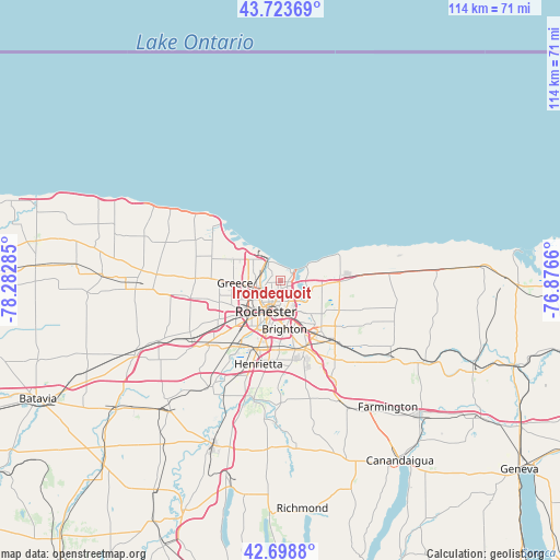
Irondequoit GPS coordinates[2]
43° 12' 48.24" North, 77° 34' 46.992" West
| Map corner | latitude | longitude |
|---|---|---|
| Upper-left | 43.72369°, | -78.28285° |
| Center: | 43.2134°, | -77.57972° |
| Lower-right: | 42.6988°, | -76.8766° |
| Map W x H: | 114×114 km | = 70.8×70.8mi |
| max Lat: | 71.29058° ⇑15.1% North |
| Irondequoit: | 43.2134° |
| min Lat: | ⇓84.9% South 19.06759° |
| min Long | Irondequoit | max Long |
| -171.73463° | -77.57972° | -66.98998° |
| W 78.7%⇐ | ⇒21.3% E |
Elevation
Elevation of Irondequoit is 117 m = 384 ft, and this is 177.8 m = 583 ft below average elevation for this country.
| Max E: |
3189 m = 10463 ft | 67.1% |
| Avg. | 294.8 m = 967 ft | |
| Irondequoit | 117 m = 384 ft | |
Min E: |
-60 m = -197 ft | 32.9% |
See also: Irondequoit elevation on elevation.city.
Geographical zone
Irondequoit is located in North temperate zone (between Tropic of Cancer and the Arctic Circle). Distance of this Northern Tropic circle is 2199 km =1366.4 mi to South.| Distance of | km | miles | from Irondequoit |
|---|---|---|---|
| North Pole | 5202.2 | 3232.5 | to North |
| Arctic Circle | 2596.3 | 1613.3 | to North |
| Tropic Cancer | 2199 | 1366.4 | to South |
| Equator | 4804.9 | 2985.6 | to South |


Nearby cities:
15 places around Irondequoit: (largest is in red/bold)
• Brighton
7.7 km =4.8 mi,  162°
162°
• Churchville
27.5 km =17.1 mi,  243°
243°
• East Rochester
13.8 km =8.6 mi,  147°
147°
• Fairport
17 km =10.6 mi,  138°
138°
• Gates-North Gates
11.2 km =7 mi, 241°
• Greece
9.2 km =5.7 mi,  267°
267°
• Hilton
19.2 km =11.9 mi,  295°
295°
• Macedon
27.9 km =17.3 mi,  125°
125°
• North Gates
10.7 km =6.6 mi,  247°
247°
• Ontario
24.1 km =15 mi,  88°
88°
• Pittsford
14.6 km =9.1 mi, 158°
• Rochester
7.1 km =4.4 mi,  204°
204°
• Scottsville
24.8 km =15.4 mi,  212°
212°
• Spencerport
18.4 km =11.4 mi,  260°
260°
• Webster
12.1 km =7.5 mi, 90°
Sources, notices
• [Note1] Compared only with cities in United States existing in our database
• [Src1] Map data: © OpenStreetMap contributors (CC-BY-SA)
• [Src2] Other city data from geonames.org with taken over terms of usage.
• [Src3] Geographical zone / Annual Mean Temperature by Robert A. Rohde @ Wikipedia
