Hilton geodata
Hilton (New York) is a populated place; located in United States in America/New_York (GMT-4) time zone. With population of 5,921 people, there are 6458 cities with bigger population in this country. Compared to other cities in United States, 85.3% of cities are located further ↓South; 78.2% of cities are located further ←West and 72.3% of cities have higher elevation than Hilton. Note1


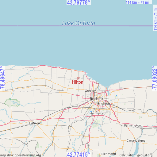
Hilton GPS coordinates[2]
43° 17' 17.232" North, 77° 47' 36.024" West
| Map corner | latitude | longitude |
|---|---|---|
| Upper-left | 43.79778°, | -78.49647° |
| Center: | 43.28812°, | -77.79334° |
| Lower-right: | 42.77415°, | -77.09022° |
| Map W x H: | 113.8×113.8 km | = 70.7×70.7mi |
| max Lat: | 71.29058° ⇑14.7% North |
| Hilton: | 43.28812° |
| min Lat: | ⇓85.3% South 19.06759° |
| min Long | Hilton | max Long |
| -171.73463° | -77.79334° | -66.98998° |
| W 78.2%⇐ | ⇒21.8% E |
Elevation
Elevation of Hilton is 87 m = 285 ft, and this is 207.8 m = 682 ft below average elevation for this country.
| Max E: |
3189 m = 10463 ft | 72.3% |
| Avg. | 294.8 m = 967 ft | |
| Hilton | 87 m = 285 ft | |
Min E: |
-60 m = -197 ft | 27.7% |
See also: United States elevation on elevation.city.
Geographical zone
Hilton is located in North temperate zone (between Tropic of Cancer and the Arctic Circle). Distance of this Northern Tropic circle is 2207.3 km =1371.6 mi to South.| Distance of | km | miles | from Hilton |
|---|---|---|---|
| North Pole | 5193.9 | 3227.3 | to North |
| Arctic Circle | 2588 | 1608.1 | to North |
| Tropic Cancer | 2207.3 | 1371.6 | to South |
| Equator | 4813.2 | 2990.8 | to South |


Nearby cities:
15 places around Hilton: (largest is in red/bold)
• Bergen
25.6 km =15.9 mi,  208°
208°
• Brighton
25.1 km =15.6 mi,  128°
128°
• Brockport
14.4 km =8.9 mi,  234°
234°
• Churchville
21.7 km =13.5 mi,  199°
199°
• Clarkson
12.5 km =7.8 mi,  240°
240°
• Gates-North Gates
15.6 km =9.7 mi,  151°
151°
• Greece
11.9 km =7.4 mi,  137°
137°
• Hamlin
10.5 km =6.5 mi,  279°
279°
• Holley
20.1 km =12.5 mi,  250°
250°
• Irondequoit
19.2 km =11.9 mi,  115°
115°
• North Gates
14.5 km =9 mi, 149°
• Rochester
20.7 km =12.9 mi, 135°
• Scottsville
29.4 km =18.3 mi,  172°
172°
• Spencerport
11.3 km =7 mi,  184°
184°
• Webster
30.6 km =19 mi,  105°
105°
Sources, notices
• [Note1] Compared only with cities in United States existing in our database
• [Src1] Map data: © OpenStreetMap contributors (CC-BY-SA)
• [Src2] Other city data from geonames.org with taken over terms of usage.
• [Src3] Geographical zone / Annual Mean Temperature by Robert A. Rohde @ Wikipedia
