Rochester geodata
Rochester (New York) is a seat of a second-order administrative division; located in United States in America/New_York (GMT-4) time zone. With population of 209,802 people, there are 116 cities with bigger population in this country. Compared to other cities in United States, 84.5% of cities are located further ↓South; 78.6% of cities are located further ←West and 59.7% of cities have higher elevation than Rochester. Note1


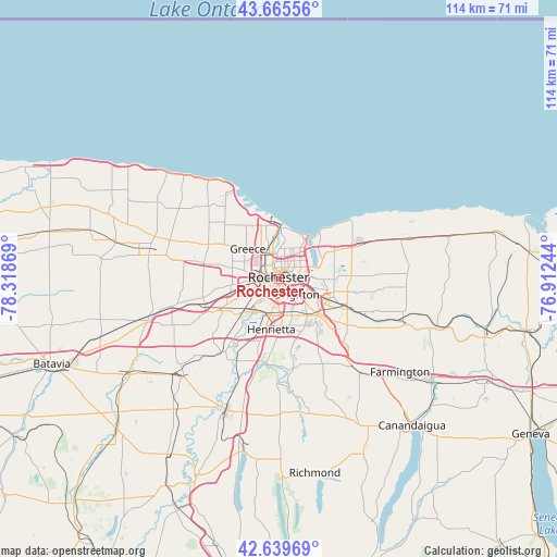
Rochester GPS coordinates[2]
43° 9' 17.208" North, 77° 36' 56.016" West
| Map corner | latitude | longitude |
|---|---|---|
| Upper-left | 43.66556°, | -78.31869° |
| Center: | 43.15478°, | -77.61556° |
| Lower-right: | 42.63969°, | -76.91244° |
| Map W x H: | 114.1×114.1 km | = 70.9×70.9mi |
| max Lat: | 71.29058° ⇑15.5% North |
| Rochester: | 43.15478° |
| min Lat: | ⇓84.5% South 19.06759° |
| min Long | Rochester | max Long |
| -171.73463° | -77.61556° | -66.98998° |
| W 78.6%⇐ | ⇒21.4% E |
Elevation
Elevation of Rochester is 156 m = 512 ft, and this is 138.8 m = 455 ft below average elevation for this country.
| Max E: |
3189 m = 10463 ft | 59.7% |
| Avg. | 294.8 m = 967 ft | |
| Rochester | 156 m = 512 ft | |
Min E: |
-60 m = -197 ft | 40.3% |
See also: Rochester elevation on elevation.city.
Geographical zone
Rochester is located in North temperate zone (between Tropic of Cancer and the Arctic Circle). Distance of this Northern Tropic circle is 2192.4 km =1362.3 mi to South.| Distance of | km | miles | from Rochester |
|---|---|---|---|
| North Pole | 5208.7 | 3236.5 | to North |
| Arctic Circle | 2602.8 | 1617.3 | to North |
| Tropic Cancer | 2192.4 | 1362.3 | to South |
| Equator | 4798.4 | 2981.6 | to South |


Nearby cities:
15 places around Rochester: (largest is in red/bold)
• Brighton
5.3 km =3.3 mi,  98°
98°
• Churchville
22.5 km =14 mi,  255°
255°
• East Rochester
11.6 km =7.2 mi,  116°
116°
• Fairport
15.4 km =9.6 mi,  113°
113°
• Gates-North Gates
7 km =4.3 mi,  279°
279°
• Greece
8.8 km =5.5 mi,  314°
314°
• Hilton
20.7 km =12.9 mi,  315°
315°
• Honeoye Falls
22.6 km =14 mi,  174°
174°
• Irondequoit
7.1 km =4.4 mi,  24°
24°
• North Gates
7.4 km =4.6 mi,  289°
289°
• Pittsford
10.8 km =6.7 mi,  131°
131°
• Scottsville
17.8 km =11.1 mi,  216°
216°
• Spencerport
15.7 km =9.8 mi, 282°
• Victor
25.5 km =15.8 mi,  138°
138°
• Webster
16.3 km =10.1 mi,  66°
66°
Sources, notices
• [Note1] Compared only with cities in United States existing in our database
• [Src1] Map data: © OpenStreetMap contributors (CC-BY-SA)
• [Src2] Other city data from geonames.org with taken over terms of usage.
• [Src3] Geographical zone / Annual Mean Temperature by Robert A. Rohde @ Wikipedia
