Throgs Neck geodata
Throgs Neck (New York) is a populated place; located in United States in America/New_York (GMT-4) time zone. With population of 33,683 people, there are 1468 cities with bigger population in this country. Compared to other cities in United States, 63.5% of cities are located further ↓South; 91.6% of cities are located further ←West and 93.9% of cities have higher elevation than Throgs Neck. Note1


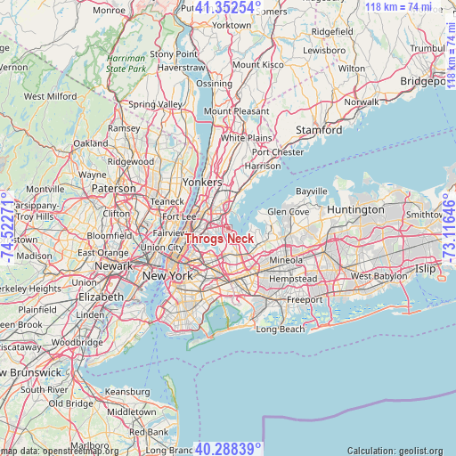
Throgs Neck GPS coordinates[2]
40° 49' 21.36" North, 73° 49' 10.488" West
| Map corner | latitude | longitude |
|---|---|---|
| Upper-left | 41.35254°, | -74.52271° |
| Center: | 40.8226°, | -73.81958° |
| Lower-right: | 40.28839°, | -73.11646° |
| Map W x H: | 118.3×118.3 km | = 73.5×73.5mi |
| max Lat: | 71.29058° ⇑36.5% North |
| Throgs Neck: | 40.8226° |
| min Lat: | ⇓63.5% South 19.06759° |
| min Long | Throgs Neck | max Long |
| -171.73463° | -73.81958° | -66.98998° |
| W 91.6%⇐ | ⇒8.4% E |
Elevation
Elevation of Throgs Neck is 10 m = 33 ft, and this is 284.8 m = 934 ft below average elevation for this country.
| Max E: |
3189 m = 10463 ft | 93.9% |
| Avg. | 294.8 m = 967 ft | |
| Throgs Neck | 10 m = 33 ft | |
Min E: |
-60 m = -197 ft | 6.1% |
See also: United States elevation on elevation.city.
Geographical zone
Throgs Neck is located in North temperate zone (between Tropic of Cancer and the Arctic Circle). Distance of this Northern Tropic circle is 1933.1 km =1201.2 mi to South.| Distance of | km | miles | from Throgs Neck |
|---|---|---|---|
| North Pole | 5468 | 3397.7 | to North |
| Arctic Circle | 2862.1 | 1778.4 | to North |
| Tropic Cancer | 1933.1 | 1201.2 | to South |
| Equator | 4539 | 2820.4 | to South |


Nearby cities:
15 places around Throgs Neck: (largest is in red/bold)
• Baychester
5.4 km =3.4 mi,  344°
344°
• Bayside
7 km =4.3 mi,  149°
149°
• City Island
3.9 km =2.4 mi,  45°
45°
• College Point
4.5 km =2.8 mi,  209°
209°
• East Tremont
6.5 km =4 mi,  292°
292°
• Hunts Point
5.5 km =3.4 mi,  258°
258°
• Kings Point
7.1 km =4.4 mi,  92°
92°
• Morris Park
4.4 km =2.7 mi,  319°
319°
• Parkchester
3.9 km =2.4 mi,  297°
297°
• Saddle Rock
6.8 km =4.2 mi,  117°
117°
• The Bronx
5 km =3.1 mi,  307°
307°
• Unionport
2.6 km =1.6 mi,  281°
281°
• Van Nest
4.7 km =2.9 mi, 307°
• West Farms
5.2 km =3.2 mi, 291°
• Whitestone
3.1 km =1.9 mi,  178°
178°
Sources, notices
• [Note1] Compared only with cities in United States existing in our database
• [Src1] Map data: © OpenStreetMap contributors (CC-BY-SA)
• [Src2] Other city data from geonames.org with taken over terms of usage.
• [Src3] Geographical zone / Annual Mean Temperature by Robert A. Rohde @ Wikipedia
