Wakefield geodata
Wakefield (New York) is a populated place; located in United States in America/New_York (GMT-4) time zone. With population of 52,201 people, there are 902 cities with bigger population in this country. Compared to other cities in United States, 64.7% of cities are located further ↓South; 91.4% of cities are located further ←West and 78.8% of cities have higher elevation than Wakefield. Note1


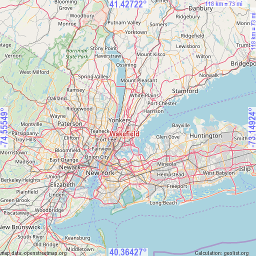
Wakefield GPS coordinates[2]
40° 53' 52.368" North, 73° 51' 8.496" West
| Map corner | latitude | longitude |
|---|---|---|
| Upper-left | 41.42722°, | -74.55549° |
| Center: | 40.89788°, | -73.85236° |
| Lower-right: | 40.36427°, | -73.14924° |
| Map W x H: | 118.2×118.2 km | = 73.4×73.4mi |
| max Lat: | 71.29058° ⇑35.3% North |
| Wakefield: | 40.89788° |
| min Lat: | ⇓64.7% South 19.06759° |
| min Long | Wakefield | max Long |
| -171.73463° | -73.85236° | -66.98998° |
| W 91.4%⇐ | ⇒8.6% E |
Elevation
Elevation of Wakefield is 52 m = 171 ft, and this is 242.8 m = 797 ft below average elevation for this country.
| Max E: |
3189 m = 10463 ft | 78.8% |
| Avg. | 294.8 m = 967 ft | |
| Wakefield | 52 m = 171 ft | |
Min E: |
-60 m = -197 ft | 21.2% |
See also: Wakefield elevation on elevation.city.
Geographical zone
Wakefield is located in North temperate zone (between Tropic of Cancer and the Arctic Circle). Distance of this Northern Tropic circle is 1941.5 km =1206.4 mi to South.| Distance of | km | miles | from Wakefield |
|---|---|---|---|
| North Pole | 5459.6 | 3392.4 | to North |
| Arctic Circle | 2853.8 | 1773.3 | to North |
| Tropic Cancer | 1941.5 | 1206.4 | to South |
| Equator | 4547.4 | 2825.6 | to South |


Nearby cities:
15 places around Wakefield: (largest is in red/bold)
• Baychester
3.4 km =2.1 mi,  157°
157°
• Bronxville
4.8 km =3 mi,  20°
20°
• Eastchester
2.4 km =1.5 mi,  122°
122°
• Fordham
5.8 km =3.6 mi,  222°
222°
• Kings Bridge
4.9 km =3 mi,  244°
244°
• Morris Park
5.1 km =3.2 mi,  181°
181°
• Mount Vernon
2.1 km =1.3 mi,  38°
38°
• Pelham
4 km =2.5 mi,  70°
70°
• Pelham Manor
3.8 km =2.4 mi,  94°
94°
• Riverdale
4.6 km =2.9 mi,  273°
273°
• Spuyten Duyvil
5.8 km =3.6 mi,  251°
251°
• The Bronx
5.5 km =3.4 mi,  192°
192°
• Van Nest
5.6 km =3.5 mi, 189°
• Woodlawn
1.3 km =0.8 mi, 271°
• Yonkers
5.4 km =3.4 mi,  313°
313°
Sources, notices
• [Note1] Compared only with cities in United States existing in our database
• [Src1] Map data: © OpenStreetMap contributors (CC-BY-SA)
• [Src2] Other city data from geonames.org with taken over terms of usage.
• [Src3] Geographical zone / Annual Mean Temperature by Robert A. Rohde @ Wikipedia
