Yonkers geodata
Yonkers (New York) is a populated place; located in United States in America/New_York (GMT-4) time zone. With population of 201,116 people, there are 125 cities with bigger population in this country. Compared to other cities in United States, 65.1% of cities are located further ↓South; 91.2% of cities are located further ←West and 83.6% of cities have higher elevation than Yonkers. Note1


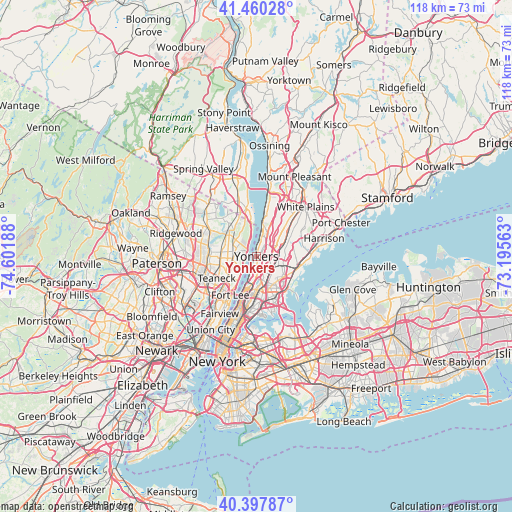
Yonkers GPS coordinates[2]
40° 55' 52.356" North, 73° 53' 55.5" West
| Map corner | latitude | longitude |
|---|---|---|
| Upper-left | 41.46028°, | -74.60188° |
| Center: | 40.93121°, | -73.89875° |
| Lower-right: | 40.39787°, | -73.19563° |
| Map W x H: | 118.1×118.1 km | = 73.4×73.4mi |
| max Lat: | 71.29058° ⇑34.9% North |
| Yonkers: | 40.93121° |
| min Lat: | ⇓65.1% South 19.06759° |
| min Long | Yonkers | max Long |
| -171.73463° | -73.89875° | -66.98998° |
| W 91.2%⇐ | ⇒8.8% E |
Elevation
Elevation of Yonkers is 33 m = 108 ft, and this is 261.8 m = 859 ft below average elevation for this country.
| Max E: |
3189 m = 10463 ft | 83.6% |
| Avg. | 294.8 m = 967 ft | |
| Yonkers | 33 m = 108 ft | |
Min E: |
-60 m = -197 ft | 16.4% |
See also: Yonkers elevation on elevation.city.
Geographical zone
Yonkers is located in North temperate zone (between Tropic of Cancer and the Arctic Circle). Distance of this Northern Tropic circle is 1945.2 km =1208.7 mi to South.| Distance of | km | miles | from Yonkers |
|---|---|---|---|
| North Pole | 5455.9 | 3390.1 | to North |
| Arctic Circle | 2850.1 | 1771 | to North |
| Tropic Cancer | 1945.2 | 1208.7 | to South |
| Equator | 4551.1 | 2827.9 | to South |


Nearby cities:
15 places around Yonkers: (largest is in red/bold)
• Alpine
3.9 km =2.4 mi,  315°
315°
• Bronxville
5.7 km =3.5 mi,  82°
82°
• Closter
7 km =4.3 mi,  311°
311°
• Cresskill
5.2 km =3.2 mi,  282°
282°
• Demarest
6.2 km =3.9 mi,  298°
298°
• Englewood Cliffs
6.8 km =4.2 mi,  221°
221°
• Hastings-on-Hudson
7.2 km =4.5 mi,  13°
13°
• Kings Bridge
5.9 km =3.7 mi,  185°
185°
• Mount Vernon
5.6 km =3.5 mi,  111°
111°
• Riverdale
3.5 km =2.2 mi, 190°
• Spuyten Duyvil
5.8 km =3.6 mi,  195°
195°
• Tenafly
5.4 km =3.4 mi,  263°
263°
• Tuckahoe
6.4 km =4 mi,  70°
70°
• Wakefield
5.4 km =3.4 mi,  133°
133°
• Woodlawn
4.5 km =2.8 mi,  144°
144°
Sources, notices
• [Note1] Compared only with cities in United States existing in our database
• [Src1] Map data: © OpenStreetMap contributors (CC-BY-SA)
• [Src2] Other city data from geonames.org with taken over terms of usage.
• [Src3] Geographical zone / Annual Mean Temperature by Robert A. Rohde @ Wikipedia
