Youngstown geodata
Youngstown (New York) is a populated place; located in United States in America/New_York (GMT-4) time zone. With population of 1,921 people, there are 12174 cities with bigger population in this country. Compared to other cities in United States, 85.1% of cities are located further ↓South; 75.6% of cities are located further ←West and 71.5% of cities have higher elevation than Youngstown. Note1


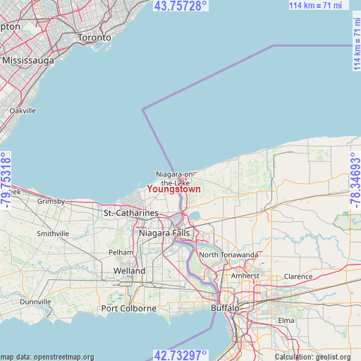
Youngstown GPS coordinates[2]
43° 14' 50.208" North, 79° 3' 0.18" West
| Map corner | latitude | longitude |
|---|---|---|
| Upper-left | 43.75728°, | -79.75318° |
| Center: | 43.24728°, | -79.05005° |
| Lower-right: | 42.73297°, | -78.34693° |
| Map W x H: | 113.9×113.9 km | = 70.8×70.8mi |
| max Lat: | 71.29058° ⇑14.9% North |
| Youngstown: | 43.24728° |
| min Lat: | ⇓85.1% South 19.06759° |
| min Long | Youngstown | max Long |
| -171.73463° | -79.05005° | -66.98998° |
| W 75.6%⇐ | ⇒24.4% E |
Elevation
Elevation of Youngstown is 92 m = 302 ft, and this is 202.8 m = 665 ft below average elevation for this country.
| Max E: |
3189 m = 10463 ft | 71.5% |
| Avg. | 294.8 m = 967 ft | |
| Youngstown | 92 m = 302 ft | |
Min E: |
-60 m = -197 ft | 28.5% |
See also: United States elevation on elevation.city.
Geographical zone
Youngstown is located in North temperate zone (between Tropic of Cancer and the Arctic Circle). Distance of this Northern Tropic circle is 2202.7 km =1368.7 mi to South.| Distance of | km | miles | from Youngstown |
|---|---|---|---|
| North Pole | 5198.4 | 3230.1 | to North |
| Arctic Circle | 2592.5 | 1610.9 | to North |
| Tropic Cancer | 2202.7 | 1368.7 | to South |
| Equator | 4808.6 | 2987.9 | to South |


Nearby cities:
15 places around Youngstown: (largest is in red/bold)
• Amherst
36.1 km =22.4 mi,  145°
145°
• Grand Island
24.8 km =15.4 mi,  163°
163°
• Grandyle Village
28.9 km =18 mi, 164°
• Kenmore
34.5 km =21.4 mi, 154°
• Lewiston
8.4 km =5.2 mi,  172°
172°
• Lockport
30.4 km =18.9 mi,  106°
106°
• Newfane
27.9 km =17.3 mi,  80°
80°
• Niagara Falls
17 km =10.6 mi,  181°
181°
• North Tonawanda
27.7 km =17.2 mi, 146°
• Olcott
28.9 km =18 mi,  69°
69°
• Ransomville
11.4 km =7.1 mi,  94°
94°
• Sanborn
18.2 km =11.3 mi,  132°
132°
• South Lockport
30.6 km =19 mi, 110°
• Tonawanda
28.7 km =17.8 mi, 151°
• Wilson
19.4 km =12.1 mi, 69°
Sources, notices
• [Note1] Compared only with cities in United States existing in our database
• [Src1] Map data: © OpenStreetMap contributors (CC-BY-SA)
• [Src2] Other city data from geonames.org with taken over terms of usage.
• [Src3] Geographical zone / Annual Mean Temperature by Robert A. Rohde @ Wikipedia
