Grand Island geodata
Grand Island (New York) is a populated place; located in United States in America/New_York (GMT-4) time zone. With population of 20,813 people, there are 2419 cities with bigger population in this country. Compared to other cities in United States, 83.5% of cities are located further ↓South; 75.8% of cities are located further ←West and 55.5% of cities have higher elevation than Grand Island. Note1


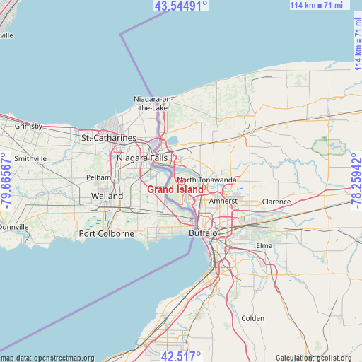
Grand Island GPS coordinates[2]
43° 1' 59.196" North, 78° 57' 45.144" West
| Map corner | latitude | longitude |
|---|---|---|
| Upper-left | 43.54491°, | -79.66567° |
| Center: | 43.03311°, | -78.96254° |
| Lower-right: | 42.517°, | -78.25942° |
| Map W x H: | 114.3×114.3 km | = 71×71mi |
| max Lat: | 71.29058° ⇑16.5% North |
| Grand Island: | 43.03311° |
| min Lat: | ⇓83.5% South 19.06759° |
| min Long | Grand Island | max Long |
| -171.73463° | -78.96254° | -66.98998° |
| W 75.8%⇐ | ⇒24.2% E |
Elevation
Elevation of Grand Island is 178 m = 584 ft, and this is 116.8 m = 383 ft below average elevation for this country.
| Max E: |
3189 m = 10463 ft | 55.5% |
| Avg. | 294.8 m = 967 ft | |
| Grand Island | 178 m = 584 ft | |
Min E: |
-60 m = -197 ft | 44.5% |
See also: United States elevation on elevation.city.
Geographical zone
Grand Island is located in North temperate zone (between Tropic of Cancer and the Arctic Circle). Distance of this Northern Tropic circle is 2178.9 km =1353.9 mi to South.| Distance of | km | miles | from Grand Island |
|---|---|---|---|
| North Pole | 5222.2 | 3244.9 | to North |
| Arctic Circle | 2616.3 | 1625.7 | to North |
| Tropic Cancer | 2178.9 | 1353.9 | to South |
| Equator | 4784.8 | 2973.1 | to South |


Nearby cities:
15 places around Grand Island: (largest is in red/bold)
• Amherst
14.6 km =9.1 mi,  114°
114°
• Buffalo
17.7 km =11 mi,  157°
157°
• Cheektowaga
22.2 km =13.8 mi,  130°
130°
• Eggertsville
15 km =9.3 mi,  121°
121°
• Grandyle Village
4.1 km =2.5 mi,  171°
171°
• Kenmore
10.6 km =6.6 mi, 134°
• Lewiston
16.6 km =10.3 mi,  338°
338°
• Niagara Falls
10.3 km =6.4 mi,  311°
311°
• North Tonawanda
8 km =5 mi,  85°
85°
• Ransomville
23.3 km =14.5 mi,  10°
10°
• Sanborn
13.1 km =8.1 mi,  28°
28°
• Sloan
20.7 km =12.9 mi,  138°
138°
• Tonawanda
6.8 km =4.2 mi,  102°
102°
• West Seneca
24.3 km =15.1 mi,  146°
146°
• Williamsville
19.8 km =12.3 mi, 112°
Sources, notices
• [Note1] Compared only with cities in United States existing in our database
• [Src1] Map data: © OpenStreetMap contributors (CC-BY-SA)
• [Src2] Other city data from geonames.org with taken over terms of usage.
• [Src3] Geographical zone / Annual Mean Temperature by Robert A. Rohde @ Wikipedia
