Amherst geodata
Amherst (New York) is a populated place; located in United States in America/New_York (GMT-4) time zone. With population of 122,366 people, there are 255 cities with bigger population in this country. Compared to other cities in United States, 83.1% of cities are located further ↓South; 76.3% of cities are located further ←West and 54.5% of cities have higher elevation than Amherst. Note1


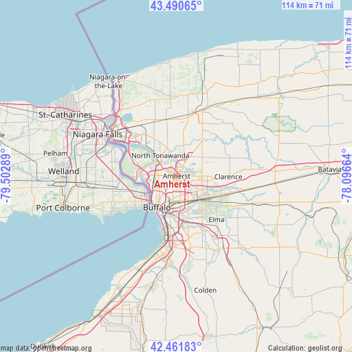
Amherst GPS coordinates[2]
42° 58' 42.204" North, 78° 47' 59.136" West
| Map corner | latitude | longitude |
|---|---|---|
| Upper-left | 43.49065°, | -79.50289° |
| Center: | 42.97839°, | -78.79976° |
| Lower-right: | 42.46183°, | -78.09664° |
| Map W x H: | 114.4×114.4 km | = 71.1×71.1mi |
| max Lat: | 71.29058° ⇑16.9% North |
| Amherst: | 42.97839° |
| min Lat: | ⇓83.1% South 19.06759° |
| min Long | Amherst | max Long |
| -171.73463° | -78.79976° | -66.98998° |
| W 76.3%⇐ | ⇒23.7% E |
Elevation
Elevation of Amherst is 182 m = 597 ft, and this is 112.8 m = 370 ft below average elevation for this country.
| Max E: |
3189 m = 10463 ft | 54.5% |
| Avg. | 294.8 m = 967 ft | |
| Amherst | 182 m = 597 ft | |
Min E: |
-60 m = -197 ft | 45.5% |
See also: Amherst elevation on elevation.city.
Geographical zone
Amherst is located in North temperate zone (between Tropic of Cancer and the Arctic Circle). Distance of this Northern Tropic circle is 2172.8 km =1350.1 mi to South.| Distance of | km | miles | from Amherst |
|---|---|---|---|
| North Pole | 5228.3 | 3248.7 | to North |
| Arctic Circle | 2622.4 | 1629.5 | to North |
| Tropic Cancer | 2172.8 | 1350.1 | to South |
| Equator | 4778.7 | 2969.3 | to South |


Nearby cities:
15 places around Amherst: (largest is in red/bold)
• Buffalo
12.1 km =7.5 mi,  212°
212°
• Cheektowaga
9.1 km =5.7 mi,  156°
156°
• Clarence Center
13.7 km =8.5 mi,  74°
74°
• Depew
12 km =7.5 mi,  133°
133°
• Eggertsville
1.7 km =1.1 mi,  191°
191°
• Grand Island
14.6 km =9.1 mi,  294°
294°
• Grandyle Village
12.8 km =8 mi,  279°
279°
• Harris Hill
10.1 km =6.3 mi,  98°
98°
• Kenmore
5.9 km =3.7 mi,  256°
256°
• Lancaster
13.6 km =8.5 mi, 129°
• North Tonawanda
8.5 km =5.3 mi,  321°
321°
• Sloan
9.5 km =5.9 mi,  177°
177°
• Tonawanda
8 km =5 mi,  305°
305°
• West Seneca
14.3 km =8.9 mi, 179°
• Williamsville
5.3 km =3.3 mi,  107°
107°
Sources, notices
• [Note1] Compared only with cities in United States existing in our database
• [Src1] Map data: © OpenStreetMap contributors (CC-BY-SA)
• [Src2] Other city data from geonames.org with taken over terms of usage.
• [Src3] Geographical zone / Annual Mean Temperature by Robert A. Rohde @ Wikipedia
