Apple Creek geodata
Apple Creek (Ohio) is a populated place; located in United States in America/New_York (GMT-4) time zone. With population of 1,184 people, there are 15208 cities with bigger population in this country. Compared to other cities in United States, 62.4% of cities are located further ↓South; 66.1% of cities are located further ←West and 76.3% of cities have lower elevation than Apple Creek. Note1


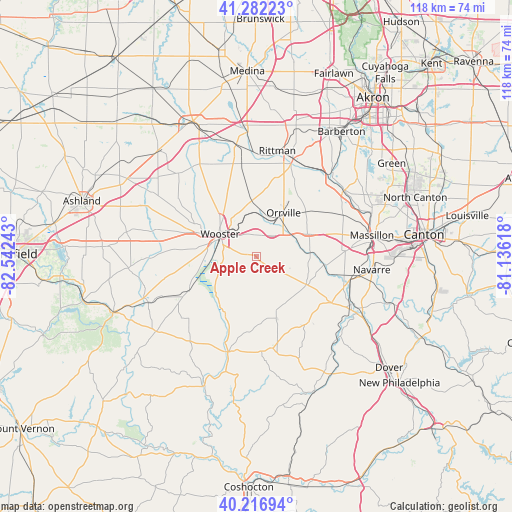
Apple Creek GPS coordinates[2]
40° 45' 6.192" North, 81° 50' 21.48" West
| Map corner | latitude | longitude |
|---|---|---|
| Upper-left | 41.28223°, | -82.54243° |
| Center: | 40.75172°, | -81.8393° |
| Lower-right: | 40.21694°, | -81.13618° |
| Map W x H: | 118.4×118.4 km | = 73.6×73.6mi |
| max Lat: | 71.29058° ⇑37.6% North |
| Apple Creek: | 40.75172° |
| min Lat: | ⇓62.4% South 19.06759° |
| min Long | Apple Creek | max Long |
| -171.73463° | -81.8393° | -66.98998° |
| W 66.1%⇐ | ⇒33.9% E |
Elevation
Elevation of Apple Creek is 322 m = 1056 ft, and this is 27.2 m = 89 ft above average elevation for this country.
| Max E: |
3189 m = 10463 ft | 23.7% |
| Apple Creek | 322 m 1056 ft | |
| Avg. | 294.8 m = 967 ft | |
Min E: |
-60 m = -197 ft | 76.3% |
See also: United States elevation on elevation.city.
Geographical zone
Apple Creek is located in North temperate zone (between Tropic of Cancer and the Arctic Circle). Distance of this Northern Tropic circle is 1925.2 km =1196.3 mi to South.| Distance of | km | miles | from Apple Creek |
|---|---|---|---|
| North Pole | 5475.9 | 3402.6 | to North |
| Arctic Circle | 2870 | 1783.3 | to North |
| Tropic Cancer | 1925.2 | 1196.3 | to South |
| Equator | 4531.2 | 2815.6 | to South |


Nearby cities:
15 places around Apple Creek: (largest is in red/bold)
• Beach City
24.4 km =15.2 mi,  116°
116°
• Berlin
21.5 km =13.4 mi,  169°
169°
• Brewster
20.9 km =13 mi,  103°
103°
• Canal Fulton
25.5 km =15.8 mi,  52°
52°
• Clinton
26.2 km =16.3 mi,  42°
42°
• Dalton
13.2 km =8.2 mi,  66°
66°
• Kidron
8 km =5 mi, 98°
• Marshallville
18.9 km =11.7 mi,  27°
27°
• Millersburg
22.9 km =14.2 mi,  196°
196°
• Orrville
12 km =7.5 mi, 31°
• Rittman
25.6 km =15.9 mi,  10°
10°
• Shreve
17.3 km =10.7 mi,  243°
243°
• Smithville
12.4 km =7.7 mi,  351°
351°
• Walnut Creek
25.4 km =15.8 mi,  157°
157°
• Wooster
10.1 km =6.3 mi,  305°
305°
Sources, notices
• [Note1] Compared only with cities in United States existing in our database
• [Src1] Map data: © OpenStreetMap contributors (CC-BY-SA)
• [Src2] Other city data from geonames.org with taken over terms of usage.
• [Src3] Geographical zone / Annual Mean Temperature by Robert A. Rohde @ Wikipedia
