Shreve geodata
Shreve (Ohio) is a populated place; located in United States in America/New_York (GMT-4) time zone. With population of 1,497 people, there are 13666 cities with bigger population in this country. Compared to other cities in United States, 61.3% of cities are located further ↓South; 65.4% of cities are located further ←West and 67.6% of cities have lower elevation than Shreve. Note1


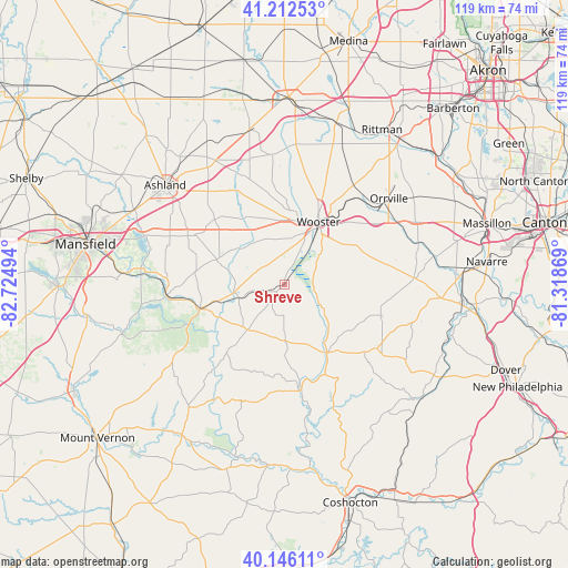
Shreve GPS coordinates[2]
40° 40' 53.22" North, 82° 1' 18.516" West
| Map corner | latitude | longitude |
|---|---|---|
| Upper-left | 41.21253°, | -82.72494° |
| Center: | 40.68145°, | -82.02181° |
| Lower-right: | 40.14611°, | -81.31869° |
| Map W x H: | 118.6×118.6 km | = 73.7×73.7mi |
| max Lat: | 71.29058° ⇑38.7% North |
| Shreve: | 40.68145° |
| min Lat: | ⇓61.3% South 19.06759° |
| min Long | Shreve | max Long |
| -171.73463° | -82.02181° | -66.98998° |
| W 65.4%⇐ | ⇒34.6% E |
Elevation
Elevation of Shreve is 274 m = 899 ft, and this is 20.8 m = 68 ft below average elevation for this country.
| Max E: |
3189 m = 10463 ft | 32.4% |
| Avg. | 294.8 m = 967 ft | |
| Shreve | 274 m = 899 ft | |
Min E: |
-60 m = -197 ft | 67.6% |
See also: United States elevation on elevation.city.
Geographical zone
Shreve is located in North temperate zone (between Tropic of Cancer and the Arctic Circle). Distance of this Northern Tropic circle is 1917.4 km =1191.4 mi to South.| Distance of | km | miles | from Shreve |
|---|---|---|---|
| North Pole | 5483.7 | 3407.4 | to North |
| Arctic Circle | 2877.8 | 1788.2 | to North |
| Tropic Cancer | 1917.4 | 1191.4 | to South |
| Equator | 4523.4 | 2810.7 | to South |


Nearby cities:
15 places around Shreve: (largest is in red/bold)
• Apple Creek
17.3 km =10.7 mi,  63°
63°
• Ashland
32.5 km =20.2 mi,  309°
309°
• Berlin
23.4 km =14.5 mi,  124°
124°
• Dalton
30.4 km =18.9 mi, 64°
• Danville
32.9 km =20.4 mi,  217°
217°
• Jeromesville
20 km =12.4 mi, 312°
• Kidron
24.3 km =15.1 mi,  74°
74°
• Killbuck
21 km =13 mi,  171°
171°
• Loudonville
18.6 km =11.6 mi,  253°
253°
• Millersburg
16.6 km =10.3 mi,  148°
148°
• Orrville
28.2 km =17.5 mi,  50°
50°
• Perrysville
24.6 km =15.3 mi,  263°
263°
• Smithville
24.2 km =15 mi,  33°
33°
• Walnut Creek
29.7 km =18.5 mi, 121°
• Wooster
15.5 km =9.6 mi, 27°
Sources, notices
• [Note1] Compared only with cities in United States existing in our database
• [Src1] Map data: © OpenStreetMap contributors (CC-BY-SA)
• [Src2] Other city data from geonames.org with taken over terms of usage.
• [Src3] Geographical zone / Annual Mean Temperature by Robert A. Rohde @ Wikipedia
