Ashley geodata
Ashley (Ohio) is a populated place; located in United States in America/New_York (GMT-4) time zone. With population of 1,361 people, there are 14298 cities with bigger population in this country. Compared to other cities in United States, 58% of cities are located further ↓South; 62.1% of cities are located further ←West and 72.6% of cities have lower elevation than Ashley. Note1


Ashley GPS coordinates[2]
40° 24' 32.22" North, 82° 57' 19.656" West
| Map corner | latitude | longitude |
|---|---|---|
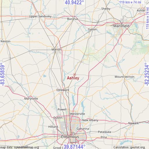
| Upper-left | 40.9422°, | -83.65859° |
| Center: | 40.40895°, | -82.95546° |
| Lower-right: | 39.87144°, | -82.25234° |
| Map W x H: | 119.1×119.1 km | = 74×74mi |
| max Lat: | 71.29058° ⇑42% North |
| Ashley: | 40.40895° |
| min Lat: | ⇓58% South 19.06759° |
| min Long | Ashley | max Long |
| -171.73463° | -82.95546° | -66.98998° |
| W 62.1%⇐ | ⇒37.9% E |
Elevation
Elevation of Ashley is 299 m = 981 ft, and this is 4.2 m = 14 ft above average elevation for this country.
| Max E: |
3189 m = 10463 ft | 27.4% |
| Ashley | 299 m 981 ft | |
| Avg. | 294.8 m = 967 ft | |
Min E: |
-60 m = -197 ft | 72.6% |
See also: United States elevation on elevation.city.
Geographical zone
Ashley is located in North temperate zone (between Tropic of Cancer and the Arctic Circle). Distance of this Northern Tropic circle is 1887.1 km =1172.6 mi to South.| Distance of | km | miles | from Ashley |
|---|---|---|---|
| North Pole | 5514 | 3426.2 | to North |
| Arctic Circle | 2908.1 | 1807 | to North |
| Tropic Cancer | 1887.1 | 1172.6 | to South |
| Equator | 4493.1 | 2791.9 | to South |


Nearby cities:
15 places around Ashley: (largest is in red/bold)
• Caledonia
25.3 km =15.7 mi,  357°
357°
• Cardington
11.5 km =7.1 mi,  27°
27°
• Centerburg
24.8 km =15.4 mi,  117°
117°
• Delaware
15.5 km =9.6 mi,  217°
217°
• Galena
22.5 km =14 mi,  163°
163°
• Lewis Center
23.9 km =14.9 mi,  191°
191°
• Marion
24.8 km =15.4 mi,  323°
323°
• Mount Gilead
19 km =11.8 mi, 34°
• Ostrander
27 km =16.8 mi,  233°
233°
• Powell
29.7 km =18.5 mi,  199°
199°
• Prospect
20.3 km =12.6 mi,  283°
283°
• Richwood
29 km =18 mi,  273°
273°
• Shawnee Hills
31.8 km =19.8 mi,  208°
208°
• Sunbury
20.2 km =12.6 mi, 156°
• Westerville
31.5 km =19.6 mi,  175°
175°
Sources, notices
• [Note1] Compared only with cities in United States existing in our database
• [Src1] Map data: © OpenStreetMap contributors (CC-BY-SA)
• [Src2] Other city data from geonames.org with taken over terms of usage.
• [Src3] Geographical zone / Annual Mean Temperature by Robert A. Rohde @ Wikipedia
