Mount Gilead geodata
Mount Gilead (Ohio) is a seat of a second-order administrative division; located in United States in America/New_York (GMT-4) time zone. With population of 3,653 people, there are 8653 cities with bigger population in this country. Compared to other cities in United States, 59.4% of cities are located further ↓South; 62.5% of cities are located further ←West and 79.5% of cities have lower elevation than Mount Gilead. Note1


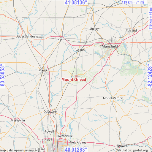
Mount Gilead GPS coordinates[2]
40° 32' 57.228" North, 82° 49' 38.64" West
| Map corner | latitude | longitude |
|---|---|---|
| Upper-left | 41.08136°, | -83.53053° |
| Center: | 40.54923°, | -82.8274° |
| Lower-right: | 40.01283°, | -82.12428° |
| Map W x H: | 118.8×118.8 km | = 73.8×73.8mi |
| max Lat: | 71.29058° ⇑40.6% North |
| Mount Gilead: | 40.54923° |
| min Lat: | ⇓59.4% South 19.06759° |
| min Long | Mount Gilead | max Long |
| -171.73463° | -82.8274° | -66.98998° |
| W 62.5%⇐ | ⇒37.5% E |
Elevation
Elevation of Mount Gilead is 348 m = 1142 ft, and this is 53.2 m = 175 ft above average elevation for this country.
| Max E: |
3189 m = 10463 ft | 20.5% |
| Mount Gilead | 348 m 1142 ft | |
| Avg. | 294.8 m = 967 ft | |
Min E: |
-60 m = -197 ft | 79.5% |
See also: United States elevation on elevation.city.
Geographical zone
Mount Gilead is located in North temperate zone (between Tropic of Cancer and the Arctic Circle). Distance of this Northern Tropic circle is 1902.7 km =1182.3 mi to South.| Distance of | km | miles | from Mount Gilead |
|---|---|---|---|
| North Pole | 5498.4 | 3416.5 | to North |
| Arctic Circle | 2892.5 | 1797.3 | to North |
| Tropic Cancer | 1902.7 | 1182.3 | to South |
| Equator | 4508.7 | 2801.6 | to South |


Nearby cities:
15 places around Mount Gilead: (largest is in red/bold)
• Ashley
19 km =11.8 mi,  214°
214°
• Bellville
27.9 km =17.3 mi,  73°
73°
• Bucyrus
31.4 km =19.5 mi,  336°
336°
• Caledonia
15.4 km =9.6 mi,  309°
309°
• Cardington
7.8 km =4.8 mi,  225°
225°
• Centerburg
29.4 km =18.3 mi,  157°
157°
• Crestline
27.6 km =17.1 mi,  16°
16°
• Fredericktown
25.4 km =15.8 mi,  107°
107°
• Galion
20.8 km =12.9 mi,  8°
8°
• Lexington
25.2 km =15.7 mi,  55°
55°
• Marion
25.8 km =16 mi,  279°
279°
• Mount Vernon
33.7 km =20.9 mi,  120°
120°
• Ontario
30.8 km =19.1 mi,  40°
40°
• Prospect
32.5 km =20.2 mi,  250°
250°
• Sunbury
34.2 km =21.3 mi,  184°
184°
Sources, notices
• [Note1] Compared only with cities in United States existing in our database
• [Src1] Map data: © OpenStreetMap contributors (CC-BY-SA)
• [Src2] Other city data from geonames.org with taken over terms of usage.
• [Src3] Geographical zone / Annual Mean Temperature by Robert A. Rohde @ Wikipedia
