Attica geodata
Attica (Ohio) is a populated place; located in United States in America/New_York (GMT-4) time zone. With population of 879 people, there are 17121 cities with bigger population in this country. Compared to other cities in United States, 66.6% of cities are located further ↓South; 62.3% of cities are located further ←West and 70.6% of cities have lower elevation than Attica. Note1


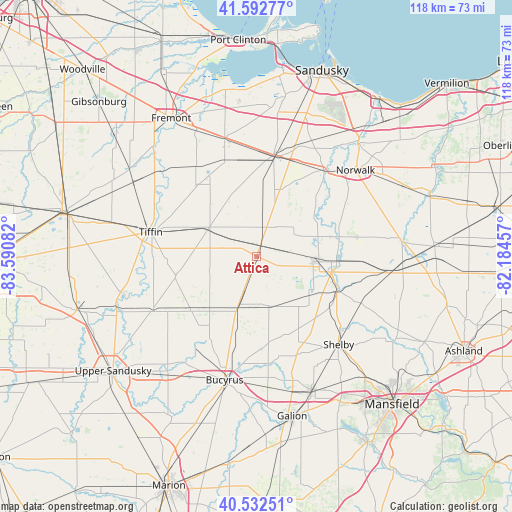
Attica GPS coordinates[2]
41° 3' 53.208" North, 82° 53' 15.684" West
| Map corner | latitude | longitude |
|---|---|---|
| Upper-left | 41.59277°, | -83.59082° |
| Center: | 41.06478°, | -82.88769° |
| Lower-right: | 40.53251°, | -82.18457° |
| Map W x H: | 117.9×117.9 km | = 73.3×73.3mi |
| max Lat: | 71.29058° ⇑33.4% North |
| Attica: | 41.06478° |
| min Lat: | ⇓66.6% South 19.06759° |
| min Long | Attica | max Long |
| -171.73463° | -82.88769° | -66.98998° |
| W 62.3%⇐ | ⇒37.7% E |
Elevation
Elevation of Attica is 289 m = 948 ft, and this is 5.8 m = 19 ft below average elevation for this country.
| Max E: |
3189 m = 10463 ft | 29.4% |
| Avg. | 294.8 m = 967 ft | |
| Attica | 289 m = 948 ft | |
Min E: |
-60 m = -197 ft | 70.6% |
See also: United States elevation on elevation.city.
Geographical zone
Attica is located in North temperate zone (between Tropic of Cancer and the Arctic Circle). Distance of this Northern Tropic circle is 1960.1 km =1217.9 mi to South.| Distance of | km | miles | from Attica |
|---|---|---|---|
| North Pole | 5441.1 | 3380.9 | to North |
| Arctic Circle | 2835.2 | 1761.7 | to North |
| Tropic Cancer | 1960.1 | 1217.9 | to South |
| Equator | 4566 | 2837.2 | to South |


Nearby cities:
15 places around Attica: (largest is in red/bold)
• Bellevue
23.5 km =14.6 mi,  9°
9°
• Bloomville
10.8 km =6.7 mi,  262°
262°
• Clyde
27.6 km =17.1 mi,  344°
344°
• Green Springs
25.3 km =15.7 mi,  327°
327°
• Monroeville
25.6 km =15.9 mi,  38°
38°
• Mount Carmel
23.3 km =14.5 mi,  349°
349°
• New Washington
11.7 km =7.3 mi,  166°
166°
• North Fairfield
23.5 km =14.6 mi,  79°
79°
• Plymouth
20 km =12.4 mi,  112°
112°
• Republic
12.5 km =7.8 mi,  300°
300°
• Shiloh
26.5 km =16.5 mi, 114°
• Sycamore
27 km =16.8 mi,  241°
241°
• Tiffin
24.9 km =15.5 mi,  282°
282°
• Waynesburg
14.1 km =8.8 mi,  145°
145°
• Willard
13.6 km =8.5 mi,  95°
95°
Sources, notices
• [Note1] Compared only with cities in United States existing in our database
• [Src1] Map data: © OpenStreetMap contributors (CC-BY-SA)
• [Src2] Other city data from geonames.org with taken over terms of usage.
• [Src3] Geographical zone / Annual Mean Temperature by Robert A. Rohde @ Wikipedia
