Clyde geodata
Clyde (Ohio) is a populated place; located in United States in America/New_York (GMT-4) time zone. With population of 6,260 people, there are 6237 cities with bigger population in this country. Compared to other cities in United States, 68.9% of cities are located further ↓South; 62.1% of cities are located further ←West and 53.7% of cities have lower elevation than Clyde. Note1


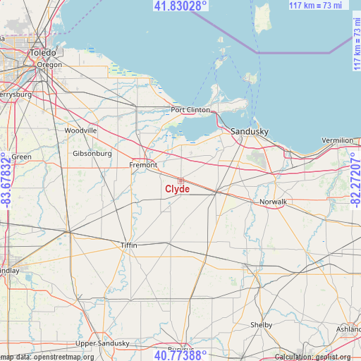
Clyde GPS coordinates[2]
41° 18' 15.192" North, 82° 58' 30.684" West
| Map corner | latitude | longitude |
|---|---|---|
| Upper-left | 41.83028°, | -83.67832° |
| Center: | 41.30422°, | -82.97519° |
| Lower-right: | 40.77388°, | -82.27207° |
| Map W x H: | 117.5×117.5 km | = 73×73mi |
| max Lat: | 71.29058° ⇑31.1% North |
| Clyde: | 41.30422° |
| min Lat: | ⇓68.9% South 19.06759° |
| min Long | Clyde | max Long |
| -171.73463° | -82.97519° | -66.98998° |
| W 62.1%⇐ | ⇒37.9% E |
Elevation
Elevation of Clyde is 213 m = 699 ft, and this is 81.8 m = 268 ft below average elevation for this country.
| Max E: |
3189 m = 10463 ft | 46.3% |
| Avg. | 294.8 m = 967 ft | |
| Clyde | 213 m = 699 ft | |
Min E: |
-60 m = -197 ft | 53.7% |
See also: United States elevation on elevation.city.
Geographical zone
Clyde is located in North temperate zone (between Tropic of Cancer and the Arctic Circle). Distance of this Northern Tropic circle is 1986.7 km =1234.5 mi to South.| Distance of | km | miles | from Clyde |
|---|---|---|---|
| North Pole | 5414.5 | 3364.4 | to North |
| Arctic Circle | 2808.6 | 1745.2 | to North |
| Tropic Cancer | 1986.7 | 1234.5 | to South |
| Equator | 4592.6 | 2853.7 | to South |


Nearby cities:
15 places around Clyde: (largest is in red/bold)
• Ballville
13.4 km =8.3 mi,  281°
281°
• Bay View
14.3 km =8.9 mi,  4°
4°
• Bay View
22.1 km =13.7 mi,  34°
34°
• Bellevue
11.7 km =7.3 mi,  106°
106°
• Bettsville
22.7 km =14.1 mi,  253°
253°
• Castalia
17.5 km =10.9 mi,  52°
52°
• Fremont
13.3 km =8.3 mi,  292°
292°
• Green Springs
8.3 km =5.2 mi,  230°
230°
• Monroeville
24.2 km =15 mi, 105°
• Mount Carmel
4.9 km =3 mi,  138°
138°
• Oak Harbor
26.7 km =16.6 mi,  327°
327°
• Port Clinton
23.3 km =14.5 mi,  7°
7°
• Republic
20.5 km =12.7 mi,  189°
189°
• Stony Prairie
15.9 km =9.9 mi, 289°
• Tiffin
27.1 km =16.8 mi,  218°
218°
Sources, notices
• [Note1] Compared only with cities in United States existing in our database
• [Src1] Map data: © OpenStreetMap contributors (CC-BY-SA)
• [Src2] Other city data from geonames.org with taken over terms of usage.
• [Src3] Geographical zone / Annual Mean Temperature by Robert A. Rohde @ Wikipedia
