Sherwood geodata
Sherwood (Ohio) is a populated place; located in United States in America/New_York (GMT-4) time zone. With population of 818 people, there are 17642 cities with bigger population in this country. Compared to other cities in United States, 68.7% of cities are located further ↓South; 57.2% of cities are located further ←West and 53.9% of cities have lower elevation than Sherwood. Note1


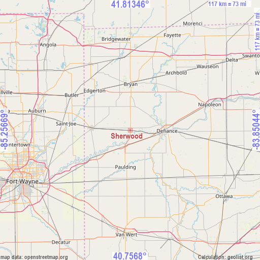
Sherwood GPS coordinates[2]
41° 17' 14.172" North, 84° 33' 12.816" West
| Map corner | latitude | longitude |
|---|---|---|
| Upper-left | 41.81346°, | -85.25669° |
| Center: | 41.28727°, | -84.55356° |
| Lower-right: | 40.7568°, | -83.85044° |
| Map W x H: | 117.5×117.5 km | = 73×73mi |
| max Lat: | 71.29058° ⇑31.3% North |
| Sherwood: | 41.28727° |
| min Lat: | ⇓68.7% South 19.06759° |
| min Long | Sherwood | max Long |
| -171.73463° | -84.55356° | -66.98998° |
| W 57.2%⇐ | ⇒42.8% E |
Elevation
Elevation of Sherwood is 214 m = 702 ft, and this is 80.8 m = 265 ft below average elevation for this country.
| Max E: |
3189 m = 10463 ft | 46.1% |
| Avg. | 294.8 m = 967 ft | |
| Sherwood | 214 m = 702 ft | |
Min E: |
-60 m = -197 ft | 53.9% |
See also: United States elevation on elevation.city.
Geographical zone
Sherwood is located in North temperate zone (between Tropic of Cancer and the Arctic Circle). Distance of this Northern Tropic circle is 1984.8 km =1233.3 mi to South.| Distance of | km | miles | from Sherwood |
|---|---|---|---|
| North Pole | 5416.3 | 3365.5 | to North |
| Arctic Circle | 2810.5 | 1746.4 | to North |
| Tropic Cancer | 1984.8 | 1233.3 | to South |
| Equator | 4590.7 | 2852.5 | to South |


Nearby cities:
15 places around Sherwood: (largest is in red/bold)
• Antwerp
19.6 km =12.2 mi,  233°
233°
• Archbold
33.2 km =20.6 mi,  38°
38°
• Bryan
20.8 km =12.9 mi,  0°
0°
• Butler
30.9 km =19.2 mi,  300°
300°
• Continental
31.8 km =19.8 mi,  130°
130°
• Defiance
16.5 km =10.3 mi,  91°
91°
• Edgerton
24.2 km =15 mi,  317°
317°
• Harlan
32.2 km =20 mi,  251°
251°
• Hicksville
17.4 km =10.8 mi,  272°
272°
• Montpelier
33.3 km =20.7 mi,  352°
352°
• Oakwood
25.8 km =16 mi,  145°
145°
• Paulding
16.7 km =10.4 mi,  187°
187°
• Payne
27.5 km =17.1 mi,  211°
211°
• Stryker
26.7 km =16.6 mi,  25°
25°
• Woodburn
30.9 km =19.2 mi, 234°
Sources, notices
• [Note1] Compared only with cities in United States existing in our database
• [Src1] Map data: © OpenStreetMap contributors (CC-BY-SA)
• [Src2] Other city data from geonames.org with taken over terms of usage.
• [Src3] Geographical zone / Annual Mean Temperature by Robert A. Rohde @ Wikipedia
