Chardon geodata
Chardon (Ohio) is a seat of a second-order administrative division; located in United States in America/New_York (GMT-4) time zone. With population of 5,148 people, there are 7044 cities with bigger population in this country. Compared to other cities in United States, 72% of cities are located further ↓South; 69% of cities are located further ←West and 83.8% of cities have lower elevation than Chardon. Note1


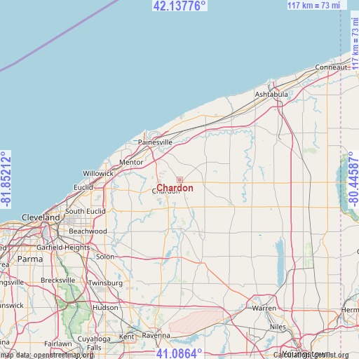
Chardon GPS coordinates[2]
41° 36' 51.192" North, 81° 8' 56.364" West
| Map corner | latitude | longitude |
|---|---|---|
| Upper-left | 42.13776°, | -81.85212° |
| Center: | 41.61422°, | -81.14899° |
| Lower-right: | 41.0864°, | -80.44587° |
| Map W x H: | 116.9×116.9 km | = 72.6×72.6mi |
| max Lat: | 71.29058° ⇑28% North |
| Chardon: | 41.61422° |
| min Lat: | ⇓72% South 19.06759° |
| min Long | Chardon | max Long |
| -171.73463° | -81.14899° | -66.98998° |
| W 69%⇐ | ⇒31% E |
Elevation
Elevation of Chardon is 401 m = 1316 ft, and this is 106.2 m = 348 ft above average elevation for this country.
| Max E: |
3189 m = 10463 ft | 16.2% |
| Chardon | 401 m 1316 ft | |
| Avg. | 294.8 m = 967 ft | |
Min E: |
-60 m = -197 ft | 83.8% |
See also: United States elevation on elevation.city.
Geographical zone
Chardon is located in North temperate zone (between Tropic of Cancer and the Arctic Circle). Distance of this Northern Tropic circle is 2021.1 km =1255.9 mi to South.| Distance of | km | miles | from Chardon |
|---|---|---|---|
| North Pole | 5380 | 3343 | to North |
| Arctic Circle | 2774.1 | 1723.7 | to North |
| Tropic Cancer | 2021.1 | 1255.9 | to South |
| Equator | 4627.1 | 2875.1 | to South |


Nearby cities:
15 places around Chardon: (largest is in red/bold)
• Burton
16 km =9.9 mi,  178°
178°
• Chesterland
18.7 km =11.6 mi,  236°
236°
• Fairport Harbor
18.3 km =11.4 mi,  325°
325°
• Kirtland
17.7 km =11 mi,  275°
275°
• Kirtland Hills
13.2 km =8.2 mi,  274°
274°
• Madison
19.3 km =12 mi,  25°
25°
• Mentor
16.9 km =10.5 mi,  290°
290°
• Mentor-on-the-Lake
20.3 km =12.6 mi,  299°
299°
• Middlefield
18 km =11.2 mi,  159°
159°
• North Madison
22.5 km =14 mi,  21°
21°
• North Perry
21.7 km =13.5 mi,  6°
6°
• Painesville
14.7 km =9.1 mi, 326°
• Perry
16.3 km =10.1 mi,  2°
2°
• Willoughby
21.6 km =13.4 mi, 277°
• Willoughby Hills
22.5 km =14 mi, 265°
Sources, notices
• [Note1] Compared only with cities in United States existing in our database
• [Src1] Map data: © OpenStreetMap contributors (CC-BY-SA)
• [Src2] Other city data from geonames.org with taken over terms of usage.
• [Src3] Geographical zone / Annual Mean Temperature by Robert A. Rohde @ Wikipedia
