Mentor-on-the-Lake geodata
Mentor-on-the-Lake (Ohio) is a populated place; located in United States in America/New_York (GMT-4) time zone. With population of 7,443 people, there are 5568 cities with bigger population in this country. Compared to other cities in United States, 73% of cities are located further ↓South; 68.3% of cities are located further ←West and 51.6% of cities have higher elevation than Mentor-on-the-Lake. Note1


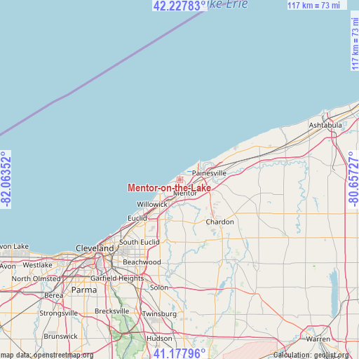
Mentor-on-the-Lake GPS coordinates[2]
41° 42' 18.144" North, 81° 21' 37.404" West
| Map corner | latitude | longitude |
|---|---|---|
| Upper-left | 42.22783°, | -82.06352° |
| Center: | 41.70504°, | -81.36039° |
| Lower-right: | 41.17796°, | -80.65727° |
| Map W x H: | 116.7×116.7 km | = 72.5×72.5mi |
| max Lat: | 71.29058° ⇑27% North |
| Mentor-on-the-Lake: | 41.70504° |
| min Lat: | ⇓73% South 19.06759° |
| min Long | Mentor-on-the-L | max Long |
| -171.73463° | -81.36039° | -66.98998° |
| W 68.3%⇐ | ⇒31.7% E |
Elevation
Elevation of Mentor-on-the-Lake is 192 m = 630 ft, and this is 102.8 m = 337 ft below average elevation for this country.
| Max E: |
3189 m = 10463 ft | 51.6% |
| Avg. | 294.8 m = 967 ft | |
| Mentor-on-the-Lake | 192 m = 630 ft | |
Min E: |
-60 m = -197 ft | 48.4% |
See also: United States elevation on elevation.city.
Geographical zone
Mentor-on-the-Lake is located in North temperate zone (between Tropic of Cancer and the Arctic Circle). Distance of this Northern Tropic circle is 2031.2 km =1262.1 mi to South.| Distance of | km | miles | from Mentor-on-the-Lake |
|---|---|---|---|
| North Pole | 5369.9 | 3336.7 | to North |
| Arctic Circle | 2764 | 1717.5 | to North |
| Tropic Cancer | 2031.2 | 1262.1 | to South |
| Equator | 4637.2 | 2881.4 | to South |


Nearby cities:
15 places around Mentor-on-the-Lake: (largest is in red/bold)
• Eastlake
9.4 km =5.8 mi,  232°
232°
• Euclid
18.6 km =11.6 mi, 228°
• Fairport Harbor
8.7 km =5.4 mi,  55°
55°
• Highland Heights
19.6 km =12.2 mi,  209°
209°
• Kirtland
8.5 km =5.3 mi,  180°
180°
• Kirtland Hills
10 km =6.2 mi,  153°
153°
• Mayfield
18.2 km =11.3 mi,  201°
201°
• Mentor
4.7 km =2.9 mi,  158°
158°
• Painesville
9.8 km =6.1 mi,  77°
77°
• Perry
19.2 km =11.9 mi,  71°
71°
• Timberlake
8.1 km =5 mi,  237°
237°
• Wickliffe
13.5 km =8.4 mi, 214°
• Willoughby
8.2 km =5.1 mi, 207°
• Willoughby Hills
12.8 km =8 mi, 202°
• Willowick
12 km =7.5 mi, 228°
Sources, notices
• [Note1] Compared only with cities in United States existing in our database
• [Src1] Map data: © OpenStreetMap contributors (CC-BY-SA)
• [Src2] Other city data from geonames.org with taken over terms of usage.
• [Src3] Geographical zone / Annual Mean Temperature by Robert A. Rohde @ Wikipedia
