Mentor geodata
Mentor (Ohio) is a populated place; located in United States in America/New_York (GMT-4) time zone. With population of 46,901 people, there are 1025 cities with bigger population in this country. Compared to other cities in United States, 72.5% of cities are located further ↓South; 68.4% of cities are located further ←West and 53.2% of cities have lower elevation than Mentor. Note1


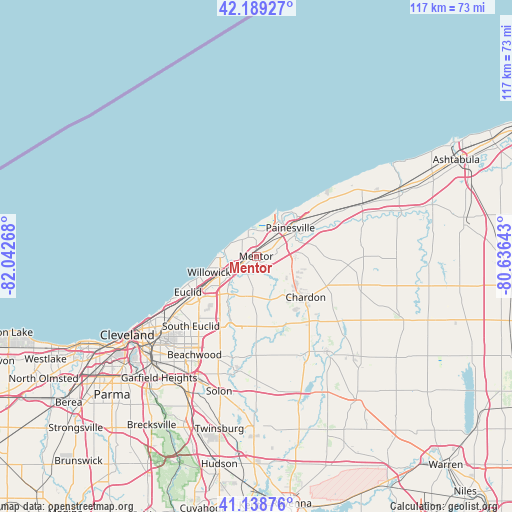
Mentor GPS coordinates[2]
41° 39' 58.176" North, 81° 20' 22.38" West
| Map corner | latitude | longitude |
|---|---|---|
| Upper-left | 42.18927°, | -82.04268° |
| Center: | 41.66616°, | -81.33955° |
| Lower-right: | 41.13876°, | -80.63643° |
| Map W x H: | 116.8×116.8 km | = 72.6×72.6mi |
| max Lat: | 71.29058° ⇑27.5% North |
| Mentor: | 41.66616° |
| min Lat: | ⇓72.5% South 19.06759° |
| min Long | Mentor | max Long |
| -171.73463° | -81.33955° | -66.98998° |
| W 68.4%⇐ | ⇒31.6% E |
Elevation
Elevation of Mentor is 211 m = 692 ft, and this is 83.8 m = 275 ft below average elevation for this country.
| Max E: |
3189 m = 10463 ft | 46.8% |
| Avg. | 294.8 m = 967 ft | |
| Mentor | 211 m = 692 ft | |
Min E: |
-60 m = -197 ft | 53.2% |
See also: Mentor elevation on elevation.city.
Geographical zone
Mentor is located in North temperate zone (between Tropic of Cancer and the Arctic Circle). Distance of this Northern Tropic circle is 2026.9 km =1259.5 mi to South.| Distance of | km | miles | from Mentor |
|---|---|---|---|
| North Pole | 5374.2 | 3339.4 | to North |
| Arctic Circle | 2768.3 | 1720.1 | to North |
| Tropic Cancer | 2026.9 | 1259.5 | to South |
| Equator | 4632.8 | 2878.7 | to South |


Nearby cities:
15 places around Mentor: (largest is in red/bold)
• Chardon
16.9 km =10.5 mi,  110°
110°
• Chesterland
16 km =9.9 mi,  179°
179°
• Eastlake
9.3 km =5.8 mi,  261°
261°
• Fairport Harbor
10.8 km =6.7 mi,  30°
30°
• Highland Heights
17.2 km =10.7 mi,  222°
222°
• Kirtland
4.5 km =2.8 mi,  203°
203°
• Kirtland Hills
5.4 km =3.4 mi,  150°
150°
• Mayfield
15.2 km =9.4 mi,  213°
213°
• Mentor-on-the-Lake
4.7 km =2.9 mi,  338°
338°
• Painesville
10.1 km =6.3 mi,  50°
50°
• Timberlake
8.6 km =5.3 mi,  269°
269°
• Wickliffe
11.6 km =7.2 mi,  234°
234°
• Willoughby
6.3 km =3.9 mi,  242°
242°
• Willoughby Hills
10 km =6.2 mi, 221°
• Willowick
11.3 km =7 mi,  251°
251°
Sources, notices
• [Note1] Compared only with cities in United States existing in our database
• [Src1] Map data: © OpenStreetMap contributors (CC-BY-SA)
• [Src2] Other city data from geonames.org with taken over terms of usage.
• [Src3] Geographical zone / Annual Mean Temperature by Robert A. Rohde @ Wikipedia
