Hartville geodata
Hartville (Ohio) is a populated place; located in United States in America/New_York (GMT-4) time zone. With population of 2,968 people, there are 9687 cities with bigger population in this country. Compared to other cities in United States, 65.5% of cities are located further ↓South; 68.4% of cities are located further ←West and 80% of cities have lower elevation than Hartville. Note1


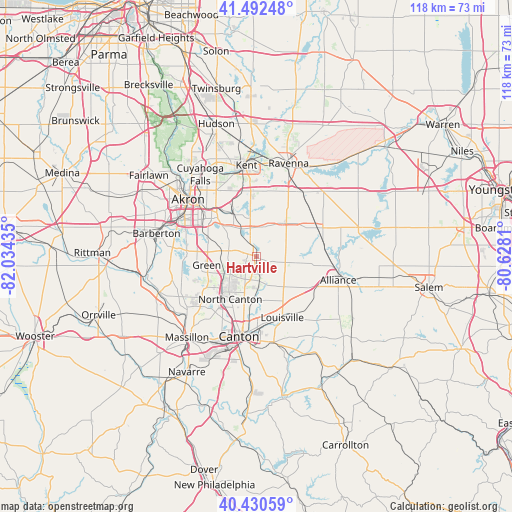
Hartville GPS coordinates[2]
40° 57' 49.212" North, 81° 19' 52.392" West
| Map corner | latitude | longitude |
|---|---|---|
| Upper-left | 41.49248°, | -82.03435° |
| Center: | 40.96367°, | -81.33122° |
| Lower-right: | 40.43059°, | -80.6281° |
| Map W x H: | 118.1×118.1 km | = 73.4×73.4mi |
| max Lat: | 71.29058° ⇑34.5% North |
| Hartville: | 40.96367° |
| min Lat: | ⇓65.5% South 19.06759° |
| min Long | Hartville | max Long |
| -171.73463° | -81.33122° | -66.98998° |
| W 68.4%⇐ | ⇒31.6% E |
Elevation
Elevation of Hartville is 354 m = 1161 ft, and this is 59.2 m = 194 ft above average elevation for this country.
| Max E: |
3189 m = 10463 ft | 20% |
| Hartville | 354 m 1161 ft | |
| Avg. | 294.8 m = 967 ft | |
Min E: |
-60 m = -197 ft | 80% |
See also: United States elevation on elevation.city.
Geographical zone
Hartville is located in North temperate zone (between Tropic of Cancer and the Arctic Circle). Distance of this Northern Tropic circle is 1948.8 km =1210.9 mi to South.| Distance of | km | miles | from Hartville |
|---|---|---|---|
| North Pole | 5452.3 | 3387.9 | to North |
| Arctic Circle | 2846.4 | 1768.7 | to North |
| Tropic Cancer | 1948.8 | 1210.9 | to South |
| Equator | 4554.7 | 2830.2 | to South |


Nearby cities:
15 places around Hartville: (largest is in red/bold)
• Atwater
15.6 km =9.7 mi,  64°
64°
• Brimfield
15.2 km =9.4 mi,  355°
355°
• Green
12.9 km =8 mi,  261°
261°
• Greensburg
11.8 km =7.3 mi,  252°
252°
• Greentown
7.2 km =4.5 mi,  236°
236°
• Lakemore
10.9 km =6.8 mi,  305°
305°
• Louisville
15.3 km =9.5 mi,  156°
156°
• Meyers Lake
18.3 km =11.4 mi,  203°
203°
• Mogadore
10.8 km =6.7 mi,  328°
328°
• New Franklin
17.8 km =11.1 mi, 262°
• North Canton
11.4 km =7.1 mi,  211°
211°
• Portage Lakes
17.1 km =10.6 mi,  286°
286°
• Sawyerwood
12.4 km =7.7 mi, 311°
• Tallmadge
17.9 km =11.1 mi, 328°
• Uniontown
6.6 km =4.1 mi,  281°
281°
Sources, notices
• [Note1] Compared only with cities in United States existing in our database
• [Src1] Map data: © OpenStreetMap contributors (CC-BY-SA)
• [Src2] Other city data from geonames.org with taken over terms of usage.
• [Src3] Geographical zone / Annual Mean Temperature by Robert A. Rohde @ Wikipedia
