Uniontown geodata
Uniontown (Ohio) is a populated place; located in United States in America/New_York (GMT-4) time zone. With population of 3,309 people, there are 9133 cities with bigger population in this country. Compared to other cities in United States, 65.6% of cities are located further ↓South; 68.1% of cities are located further ←West and 79.3% of cities have lower elevation than Uniontown. Note1


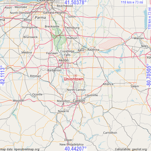
Uniontown GPS coordinates[2]
40° 58' 30.216" North, 81° 24' 29.412" West
| Map corner | latitude | longitude |
|---|---|---|
| Upper-left | 41.50378°, | -82.1113° |
| Center: | 40.97506°, | -81.40817° |
| Lower-right: | 40.44207°, | -80.70505° |
| Map W x H: | 118.1×118.1 km | = 73.4×73.4mi |
| max Lat: | 71.29058° ⇑34.4% North |
| Uniontown: | 40.97506° |
| min Lat: | ⇓65.6% South 19.06759° |
| min Long | Uniontown | max Long |
| -171.73463° | -81.40817° | -66.98998° |
| W 68.1%⇐ | ⇒31.9% E |
Elevation
Elevation of Uniontown is 347 m = 1138 ft, and this is 52.2 m = 171 ft above average elevation for this country.
| Max E: |
3189 m = 10463 ft | 20.7% |
| Uniontown | 347 m 1138 ft | |
| Avg. | 294.8 m = 967 ft | |
Min E: |
-60 m = -197 ft | 79.3% |
See also: United States elevation on elevation.city.
Geographical zone
Uniontown is located in North temperate zone (between Tropic of Cancer and the Arctic Circle). Distance of this Northern Tropic circle is 1950.1 km =1211.7 mi to South.| Distance of | km | miles | from Uniontown |
|---|---|---|---|
| North Pole | 5451.1 | 3387.2 | to North |
| Arctic Circle | 2845.2 | 1767.9 | to North |
| Tropic Cancer | 1950.1 | 1211.7 | to South |
| Equator | 4556 | 2831 | to South |


Nearby cities:
15 places around Uniontown: (largest is in red/bold)
• Akron
15 km =9.3 mi,  321°
321°
• Barberton
17.1 km =10.6 mi,  284°
284°
• Brimfield
14.8 km =9.2 mi,  20°
20°
• Green
7.1 km =4.4 mi,  242°
242°
• Greensburg
6.8 km =4.2 mi,  224°
224°
• Greentown
5.3 km =3.3 mi,  174°
174°
• Hartville
6.6 km =4.1 mi,  101°
101°
• Lakemore
5.6 km =3.5 mi,  335°
335°
• Manchester
14.2 km =8.8 mi,  252°
252°
• Mogadore
8 km =5 mi,  6°
6°
• New Franklin
11.8 km =7.3 mi, 251°
• North Canton
11 km =6.8 mi,  177°
177°
• Portage Lakes
10.6 km =6.6 mi,  289°
289°
• Sawyerwood
7.5 km =4.7 mi, 338°
• Tallmadge
14.3 km =8.9 mi,  348°
348°
Sources, notices
• [Note1] Compared only with cities in United States existing in our database
• [Src1] Map data: © OpenStreetMap contributors (CC-BY-SA)
• [Src2] Other city data from geonames.org with taken over terms of usage.
• [Src3] Geographical zone / Annual Mean Temperature by Robert A. Rohde @ Wikipedia
