Maple Ridge geodata
Maple Ridge (Ohio) is a populated place; located in United States in America/New_York (GMT-4) time zone. With population of 761 people, there are 18118 cities with bigger population in this country. Compared to other cities in United States, 65% of cities are located further ↓South; 69.3% of cities are located further ←West and 78.3% of cities have lower elevation than Maple Ridge. Note1


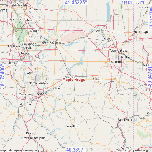
Maple Ridge GPS coordinates[2]
40° 55' 23.196" North, 81° 3' 3.348" West
| Map corner | latitude | longitude |
|---|---|---|
| Upper-left | 41.45225°, | -81.75406° |
| Center: | 40.92311°, | -81.05093° |
| Lower-right: | 40.3897°, | -80.34781° |
| Map W x H: | 118.1×118.1 km | = 73.4×73.4mi |
| max Lat: | 71.29058° ⇑35% North |
| Maple Ridge: | 40.92311° |
| min Lat: | ⇓65% South 19.06759° |
| min Long | Maple Ridge | max Long |
| -171.73463° | -81.05093° | -66.98998° |
| W 69.3%⇐ | ⇒30.7% E |
Elevation
Elevation of Maple Ridge is 338 m = 1109 ft, and this is 43.2 m = 142 ft above average elevation for this country.
| Max E: |
3189 m = 10463 ft | 21.7% |
| Maple Ridge | 338 m 1109 ft | |
| Avg. | 294.8 m = 967 ft | |
Min E: |
-60 m = -197 ft | 78.3% |
See also: United States elevation on elevation.city.
Geographical zone
Maple Ridge is located in North temperate zone (between Tropic of Cancer and the Arctic Circle). Distance of this Northern Tropic circle is 1944.3 km =1208.1 mi to South.| Distance of | km | miles | from Maple Ridge |
|---|---|---|---|
| North Pole | 5456.8 | 3390.7 | to North |
| Arctic Circle | 2851 | 1771.5 | to North |
| Tropic Cancer | 1944.3 | 1208.1 | to South |
| Equator | 4550.2 | 2827.4 | to South |


Nearby cities:
15 places around Maple Ridge: (largest is in red/bold)
• Alliance
4.7 km =2.9 mi,  259°
259°
• Atwater
14.7 km =9.1 mi,  319°
319°
• Beloit
4.8 km =3 mi,  90°
90°
• Canfield
26.9 km =16.7 mi,  65°
65°
• Craig Beach
22.3 km =13.9 mi,  14°
14°
• East Canton
24.7 km =15.3 mi,  232°
232°
• Hartville
24 km =14.9 mi,  280°
280°
• Leetonia
25.4 km =15.8 mi,  101°
101°
• Louisville
20 km =12.4 mi,  241°
241°
• Malvern
28 km =17.4 mi,  203°
203°
• Minerva
22 km =13.7 mi,  192°
192°
• Salem
16.5 km =10.3 mi, 98°
• Sebring
2.7 km =1.7 mi, 90°
• South Canal
28.8 km =17.9 mi, 10°
• Washingtonville
24.2 km =15 mi, 95°
Sources, notices
• [Note1] Compared only with cities in United States existing in our database
• [Src1] Map data: © OpenStreetMap contributors (CC-BY-SA)
• [Src2] Other city data from geonames.org with taken over terms of usage.
• [Src3] Geographical zone / Annual Mean Temperature by Robert A. Rohde @ Wikipedia
