Cygnet geodata
Cygnet (Ohio) is a populated place; located in United States in America/New_York (GMT-4) time zone. With population of 617 people, there are 19506 cities with bigger population in this country. Compared to other cities in United States, 68.2% of cities are located further ↓South; 60.2% of cities are located further ←West and 54.2% of cities have lower elevation than Cygnet. Note1


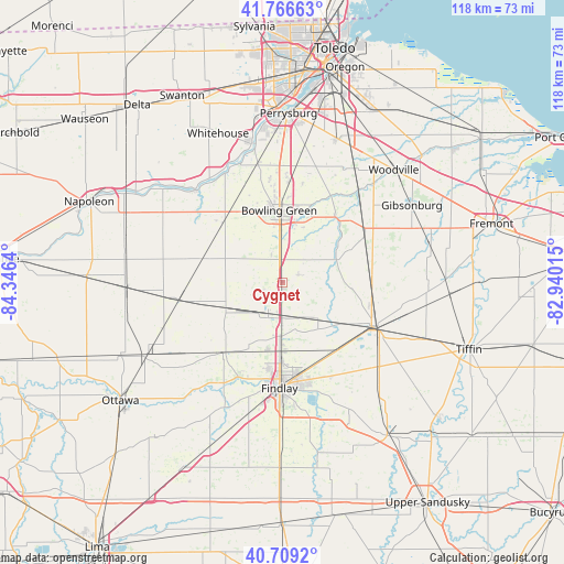
Cygnet GPS coordinates[2]
41° 14' 24.18" North, 83° 38' 35.772" West
| Map corner | latitude | longitude |
|---|---|---|
| Upper-left | 41.76663°, | -84.3464° |
| Center: | 41.24005°, | -83.64327° |
| Lower-right: | 40.7092°, | -82.94015° |
| Map W x H: | 117.6×117.6 km | = 73.1×73.1mi |
| max Lat: | 71.29058° ⇑31.8% North |
| Cygnet: | 41.24005° |
| min Lat: | ⇓68.2% South 19.06759° |
| min Long | Cygnet | max Long |
| -171.73463° | -83.64327° | -66.98998° |
| W 60.2%⇐ | ⇒39.8% E |
Elevation
Elevation of Cygnet is 215 m = 705 ft, and this is 79.8 m = 262 ft below average elevation for this country.
| Max E: |
3189 m = 10463 ft | 45.8% |
| Avg. | 294.8 m = 967 ft | |
| Cygnet | 215 m = 705 ft | |
Min E: |
-60 m = -197 ft | 54.2% |
See also: United States elevation on elevation.city.
Geographical zone
Cygnet is located in North temperate zone (between Tropic of Cancer and the Arctic Circle). Distance of this Northern Tropic circle is 1979.5 km =1230 mi to South.| Distance of | km | miles | from Cygnet |
|---|---|---|---|
| North Pole | 5421.6 | 3368.8 | to North |
| Arctic Circle | 2815.7 | 1749.6 | to North |
| Tropic Cancer | 1979.5 | 1230 | to South |
| Equator | 4585.5 | 2849.3 | to South |


Nearby cities:
15 places around Cygnet: (largest is in red/bold)
• Arcadia
18.1 km =11.2 mi,  144°
144°
• Bloomdale
10.5 km =6.5 mi, 135°
• Bowling Green
15 km =9.3 mi,  357°
357°
• Bradner
19.5 km =12.1 mi,  61°
61°
• Deshler
21.7 km =13.5 mi,  260°
260°
• Findlay
21.8 km =13.5 mi,  181°
181°
• Fostoria
21.1 km =13.1 mi,  115°
115°
• Grand Rapids
26.6 km =16.5 mi,  315°
315°
• Haskins
25.5 km =15.8 mi,  348°
348°
• McComb
19.3 km =12 mi,  220°
220°
• North Baltimore
7 km =4.3 mi,  204°
204°
• Pemberville
24.3 km =15.1 mi,  38°
38°
• Risingsun
18.5 km =11.5 mi,  79°
79°
• Wayne
15.7 km =9.8 mi, 64°
• Weston
17.3 km =10.7 mi,  312°
312°
Sources, notices
• [Note1] Compared only with cities in United States existing in our database
• [Src1] Map data: © OpenStreetMap contributors (CC-BY-SA)
• [Src2] Other city data from geonames.org with taken over terms of usage.
• [Src3] Geographical zone / Annual Mean Temperature by Robert A. Rohde @ Wikipedia
