Waynesfield geodata
Waynesfield (Ohio) is a populated place; located in United States in America/New_York (GMT-4) time zone. With population of 847 people, there are 17394 cities with bigger population in this country. Compared to other cities in United States, 60% of cities are located further ↓South; 59.3% of cities are located further ←West and 76.3% of cities have lower elevation than Waynesfield. Note1


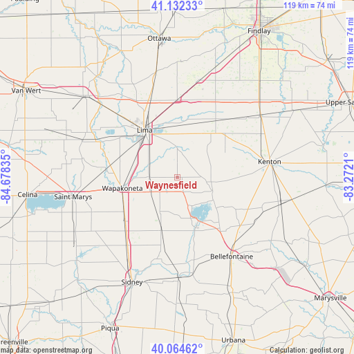
Waynesfield GPS coordinates[2]
40° 36' 2.196" North, 83° 58' 30.792" West
| Map corner | latitude | longitude |
|---|---|---|
| Upper-left | 41.13233°, | -84.67835° |
| Center: | 40.60061°, | -83.97522° |
| Lower-right: | 40.06462°, | -83.2721° |
| Map W x H: | 118.7×118.7 km | = 73.8×73.8mi |
| max Lat: | 71.29058° ⇑40% North |
| Waynesfield: | 40.60061° |
| min Lat: | ⇓60% South 19.06759° |
| min Long | Waynesfield | max Long |
| -171.73463° | -83.97522° | -66.98998° |
| W 59.3%⇐ | ⇒40.7% E |
Elevation
Elevation of Waynesfield is 322 m = 1056 ft, and this is 27.2 m = 89 ft above average elevation for this country.
| Max E: |
3189 m = 10463 ft | 23.7% |
| Waynesfield | 322 m 1056 ft | |
| Avg. | 294.8 m = 967 ft | |
Min E: |
-60 m = -197 ft | 76.3% |
See also: United States elevation on elevation.city.
Geographical zone
Waynesfield is located in North temperate zone (between Tropic of Cancer and the Arctic Circle). Distance of this Northern Tropic circle is 1908.4 km =1185.8 mi to South.| Distance of | km | miles | from Waynesfield |
|---|---|---|---|
| North Pole | 5492.7 | 3413 | to North |
| Arctic Circle | 2886.8 | 1793.8 | to North |
| Tropic Cancer | 1908.4 | 1185.8 | to South |
| Equator | 4514.4 | 2805.1 | to South |


Nearby cities:
15 places around Waynesfield: (largest is in red/bold)
• Ada
22.8 km =14.2 mi,  34°
34°
• Alger
16.1 km =10 mi,  43°
43°
• Anna
28.4 km =17.6 mi,  216°
216°
• Belle Center
21.9 km =13.6 mi,  118°
118°
• Botkins
22.8 km =14.2 mi,  229°
229°
• Cairo
27.4 km =17 mi,  340°
340°
• Chippewa Park
11.9 km =7.4 mi,  142°
142°
• Cridersville
16 km =9.9 mi,  291°
291°
• Fort Shawnee
16.7 km =10.4 mi,  304°
304°
• Jackson Center
18.7 km =11.6 mi,  197°
197°
• Lakeview
13.6 km =8.5 mi,  161°
161°
• Lima
19.2 km =11.9 mi,  325°
325°
• Northwood
25 km =15.5 mi, 124°
• Russells Point
16 km =9.9 mi,  154°
154°
• Wapakoneta
18.8 km =11.7 mi,  258°
258°
Sources, notices
• [Note1] Compared only with cities in United States existing in our database
• [Src1] Map data: © OpenStreetMap contributors (CC-BY-SA)
• [Src2] Other city data from geonames.org with taken over terms of usage.
• [Src3] Geographical zone / Annual Mean Temperature by Robert A. Rohde @ Wikipedia
