Belle Center geodata
Belle Center (Ohio) is a populated place; located in United States in America/New_York (GMT-4) time zone. With population of 798 people, there are 17827 cities with bigger population in this country. Compared to other cities in United States, 59% of cities are located further ↓South; 60% of cities are located further ←West and 75.8% of cities have lower elevation than Belle Center. Note1


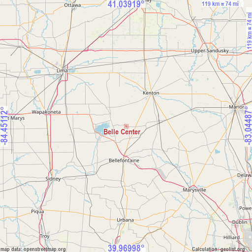
Belle Center GPS coordinates[2]
40° 30' 24.192" North, 83° 44' 52.764" West
| Map corner | latitude | longitude |
|---|---|---|
| Upper-left | 41.03919°, | -84.45112° |
| Center: | 40.50672°, | -83.74799° |
| Lower-right: | 39.96998°, | -83.04487° |
| Map W x H: | 118.9×118.9 km | = 73.9×73.9mi |
| max Lat: | 71.29058° ⇑41% North |
| Belle Center: | 40.50672° |
| min Lat: | ⇓59% South 19.06759° |
| min Long | Belle Center | max Long |
| -171.73463° | -83.74799° | -66.98998° |
| W 60%⇐ | ⇒40% E |
Elevation
Elevation of Belle Center is 319 m = 1047 ft, and this is 24.2 m = 79 ft above average elevation for this country.
| Max E: |
3189 m = 10463 ft | 24.2% |
| Belle Center | 319 m 1047 ft | |
| Avg. | 294.8 m = 967 ft | |
Min E: |
-60 m = -197 ft | 75.8% |
See also: United States elevation on elevation.city.
Geographical zone
Belle Center is located in North temperate zone (between Tropic of Cancer and the Arctic Circle). Distance of this Northern Tropic circle is 1898 km =1179.4 mi to South.| Distance of | km | miles | from Belle Center |
|---|---|---|---|
| North Pole | 5503.1 | 3419.5 | to North |
| Arctic Circle | 2897.2 | 1800.2 | to North |
| Tropic Cancer | 1898 | 1179.4 | to South |
| Equator | 4503.9 | 2798.6 | to South |


Nearby cities:
15 places around Belle Center: (largest is in red/bold)
• Alger
23.6 km =14.7 mi,  339°
339°
• Bellefontaine
16.2 km =10.1 mi,  183°
183°
• Chippewa Park
12 km =7.5 mi,  274°
274°
• De Graff
25.9 km =16.1 mi,  213°
213°
• Jackson Center
25.8 km =16 mi,  253°
253°
• Kenton
19.5 km =12.1 mi,  36°
36°
• Lakeview
15 km =9.3 mi,  260°
260°
• Mount Victory
19.5 km =12.1 mi,  80°
80°
• Northwood
4 km =2.5 mi,  160°
160°
• Quincy
29.7 km =18.5 mi,  219°
219°
• Rushsylvania
8.3 km =5.2 mi,  127°
127°
• Russells Point
12.9 km =8 mi, 252°
• Waynesfield
21.9 km =13.6 mi,  298°
298°
• West Liberty
28.3 km =17.6 mi, 181°
• West Mansfield
20.7 km =12.9 mi,  124°
124°
Sources, notices
• [Note1] Compared only with cities in United States existing in our database
• [Src1] Map data: © OpenStreetMap contributors (CC-BY-SA)
• [Src2] Other city data from geonames.org with taken over terms of usage.
• [Src3] Geographical zone / Annual Mean Temperature by Robert A. Rohde @ Wikipedia
