Austin geodata
Austin (Pennsylvania) is a populated place; located in United States in America/New_York (GMT-4) time zone. With population of 550 people, there are 20274 cities with bigger population in this country. Compared to other cities in United States, 72.1% of cities are located further ↓South; 77.6% of cities are located further ←West and 84.3% of cities have lower elevation than Austin. Note1


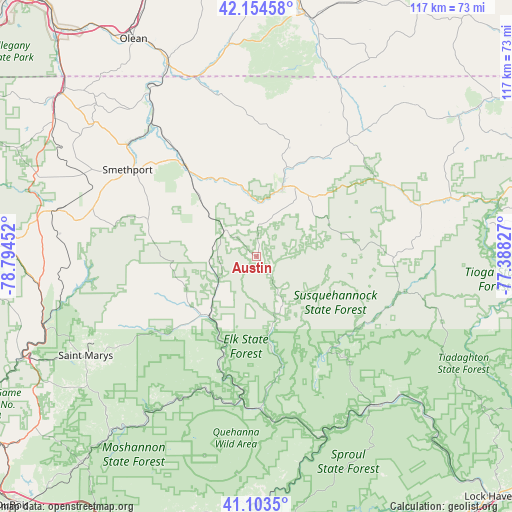
Austin GPS coordinates[2]
41° 37' 52.248" North, 78° 5' 29.004" West
| Map corner | latitude | longitude |
|---|---|---|
| Upper-left | 42.15458°, | -78.79452° |
| Center: | 41.63118°, | -78.09139° |
| Lower-right: | 41.1035°, | -77.38827° |
| Map W x H: | 116.9×116.9 km | = 72.6×72.6mi |
| max Lat: | 71.29058° ⇑27.9% North |
| Austin: | 41.63118° |
| min Lat: | ⇓72.1% South 19.06759° |
| min Long | Austin | max Long |
| -171.73463° | -78.09139° | -66.98998° |
| W 77.6%⇐ | ⇒22.4% E |
Elevation
Elevation of Austin is 410 m = 1345 ft, and this is 115.2 m = 378 ft above average elevation for this country.
| Max E: |
3189 m = 10463 ft | 15.7% |
| Austin | 410 m 1345 ft | |
| Avg. | 294.8 m = 967 ft | |
Min E: |
-60 m = -197 ft | 84.3% |
See also: United States elevation on elevation.city.
Geographical zone
Austin is located in North temperate zone (between Tropic of Cancer and the Arctic Circle). Distance of this Northern Tropic circle is 2023 km =1257 mi to South.| Distance of | km | miles | from Austin |
|---|---|---|---|
| North Pole | 5378.1 | 3341.8 | to North |
| Arctic Circle | 2772.2 | 1722.6 | to North |
| Tropic Cancer | 2023 | 1257 | to South |
| Equator | 4629 | 2876.3 | to South |


Nearby cities:
15 places around Austin: (largest is in red/bold)
• Alma
42.5 km =26.4 mi,  3°
3°
• Bolivar
48.8 km =30.3 mi,  352°
352°
• Coudersport
17 km =10.6 mi,  20°
20°
• Eldred
43.7 km =27.2 mi,  326°
326°
• Emporium
17.9 km =11.1 mi,  221°
221°
• Galeton
39 km =24.2 mi,  73°
73°
• Mount Jewett
46.6 km =29 mi,  283°
283°
• Port Allegany
25.4 km =15.8 mi,  321°
321°
• Portville
49.8 km =30.9 mi,  335°
335°
• Renovo
44.2 km =27.5 mi,  140°
140°
• Roulette
17.3 km =10.7 mi, 342°
• Saint Marys
45.1 km =28 mi,  239°
239°
• Shinglehouse
37.9 km =23.5 mi, 347°
• Smethport
35.5 km =22.1 mi,  304°
304°
• Ulysses
40.8 km =25.4 mi,  42°
42°
Sources, notices
• [Note1] Compared only with cities in United States existing in our database
• [Src1] Map data: © OpenStreetMap contributors (CC-BY-SA)
• [Src2] Other city data from geonames.org with taken over terms of usage.
• [Src3] Geographical zone / Annual Mean Temperature by Robert A. Rohde @ Wikipedia
