Chicora geodata
Chicora (Pennsylvania) is a populated place; located in United States in America/New_York (GMT-4) time zone. With population of 1,006 people, there are 16243 cities with bigger population in this country. Compared to other cities in United States, 65.3% of cities are located further ↓South; 74.4% of cities are located further ←West and 81.6% of cities have lower elevation than Chicora. Note1
Administrative division(s):
- Level 1: Pennsylvania
- Level 2: Butler County
- Level 3: Borough of Chicora


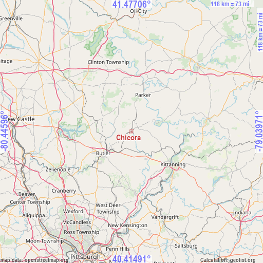
Chicora GPS coordinates[2]
40° 56' 53.232" North, 79° 44' 34.188" West
| Map corner | latitude | longitude |
|---|---|---|
| Upper-left | 41.47706°, | -80.44596° |
| Center: | 40.94812°, | -79.74283° |
| Lower-right: | 40.41491°, | -79.03971° |
| Map W x H: | 118.1×118.1 km | = 73.4×73.4mi |
| max Lat: | 71.29058° ⇑34.7% North |
| Chicora: | 40.94812° |
| min Lat: | ⇓65.3% South 19.06759° |
| min Long | Chicora | max Long |
| -171.73463° | -79.74283° | -66.98998° |
| W 74.4%⇐ | ⇒25.6% E |
Elevation
Elevation of Chicora is 372 m = 1220 ft, and this is 77.2 m = 253 ft above average elevation for this country.
| Max E: |
3189 m = 10463 ft | 18.4% |
| Chicora | 372 m 1220 ft | |
| Avg. | 294.8 m = 967 ft | |
Min E: |
-60 m = -197 ft | 81.6% |
See also: United States elevation on elevation.city.
Geographical zone
Chicora is located in North temperate zone (between Tropic of Cancer and the Arctic Circle). Distance of this Northern Tropic circle is 1947.1 km =1209.9 mi to South.| Distance of | km | miles | from Chicora |
|---|---|---|---|
| North Pole | 5454.1 | 3389 | to North |
| Arctic Circle | 2848.2 | 1769.8 | to North |
| Tropic Cancer | 1947.1 | 1209.9 | to South |
| Equator | 4553 | 2829.1 | to South |


Nearby cities:
15 places around Chicora: (largest is in red/bold)
• Bruin
11.9 km =7.4 mi,  6°
6°
• Butler
16.1 km =10 mi,  232°
232°
• East Brady
11.7 km =7.3 mi,  68°
68°
• East Butler
11.7 km =7.3 mi, 228°
• Homeacre-Lyndora
17.2 km =10.7 mi,  240°
240°
• Meadowood
17.3 km =10.7 mi, 227°
• Meridian
21.5 km =13.4 mi, 238°
• Oak Hills
19.8 km =12.3 mi, 226°
• Parker
17.2 km =10.7 mi,  17°
17°
• Rimersburg
22.6 km =14 mi,  62°
62°
• Saxonburg
22.3 km =13.9 mi,  194°
194°
• Shanor-Northvue
15.1 km =9.4 mi,  253°
253°
• Unionville
18.4 km =11.4 mi,  267°
267°
• West Hills
21.7 km =13.5 mi,  129°
129°
• Worthington
15.4 km =9.6 mi,  142°
142°
Sources, notices
• [Note1] Compared only with cities in United States existing in our database
• [Src1] Map data: © OpenStreetMap contributors (CC-BY-SA)
• [Src2] Other city data from geonames.org with taken over terms of usage.
• [Src3] Geographical zone / Annual Mean Temperature by Robert A. Rohde @ Wikipedia
