Corry geodata
Corry (Pennsylvania) is a populated place; located in United States in America/New_York (GMT-4) time zone. With population of 6,420 people, there are 6164 cities with bigger population in this country. Compared to other cities in United States, 75% of cities are located further ↓South; 74.6% of cities are located further ←West and 85.7% of cities have lower elevation than Corry. Note1


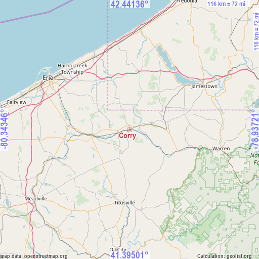
Corry GPS coordinates[2]
41° 55' 13.188" North, 79° 38' 25.188" West
| Map corner | latitude | longitude |
|---|---|---|
| Upper-left | 42.44136°, | -80.34346° |
| Center: | 41.92033°, | -79.64033° |
| Lower-right: | 41.39501°, | -78.93721° |
| Map W x H: | 116.3×116.3 km | = 72.3×72.3mi |
| max Lat: | 71.29058° ⇑25% North |
| Corry: | 41.92033° |
| min Lat: | ⇓75% South 19.06759° |
| min Long | Corry | max Long |
| -171.73463° | -79.64033° | -66.98998° |
| W 74.6%⇐ | ⇒25.4% E |
Elevation
Elevation of Corry is 437 m = 1434 ft, and this is 142.2 m = 467 ft above average elevation for this country.
| Max E: |
3189 m = 10463 ft | 14.3% |
| Corry | 437 m 1434 ft | |
| Avg. | 294.8 m = 967 ft | |
Min E: |
-60 m = -197 ft | 85.7% |
See also: United States elevation on elevation.city.
Geographical zone
Corry is located in North temperate zone (between Tropic of Cancer and the Arctic Circle). Distance of this Northern Tropic circle is 2055.2 km =1277 mi to South.| Distance of | km | miles | from Corry |
|---|---|---|---|
| North Pole | 5346 | 3321.8 | to North |
| Arctic Circle | 2740.1 | 1702.6 | to North |
| Tropic Cancer | 2055.2 | 1277 | to South |
| Equator | 4661.1 | 2896.3 | to South |


Nearby cities:
15 places around Corry: (largest is in red/bold)
• Canadohta Lake
20 km =12.4 mi,  233°
233°
• Celoron
36.2 km =22.5 mi,  54°
54°
• Clymer
11.2 km =7 mi,  4°
4°
• Columbus
5.4 km =3.4 mi,  64°
64°
• Hydetown
30.6 km =19 mi,  193°
193°
• Jamestown West
35.1 km =21.8 mi, 57°
• Lakewood
32.6 km =20.3 mi, 51°
• North East
36.5 km =22.7 mi,  334°
334°
• Sherman
26.8 km =16.7 mi,  7°
7°
• Sugar Grove
25.9 km =16.1 mi,  74°
74°
• Tidioute
32.7 km =20.3 mi,  143°
143°
• Titusville
32.7 km =20.3 mi,  184°
184°
• Union City
17.1 km =10.6 mi,  262°
262°
• Waterford
28.6 km =17.8 mi,  275°
275°
• Youngsville
27.7 km =17.2 mi,  105°
105°
Sources, notices
• [Note1] Compared only with cities in United States existing in our database
• [Src1] Map data: © OpenStreetMap contributors (CC-BY-SA)
• [Src2] Other city data from geonames.org with taken over terms of usage.
• [Src3] Geographical zone / Annual Mean Temperature by Robert A. Rohde @ Wikipedia
