Hydetown geodata
Hydetown (Pennsylvania) is a populated place; located in United States in America/New_York (GMT-4) time zone. With population of 517 people, there are 20672 cities with bigger population in this country. Compared to other cities in United States, 72.4% of cities are located further ↓South; 74.4% of cities are located further ←West and 82.6% of cities have lower elevation than Hydetown. Note1
Administrative division(s):
- Level 1: Pennsylvania
- Level 2: Crawford County
- Level 3: Borough of Hydetown


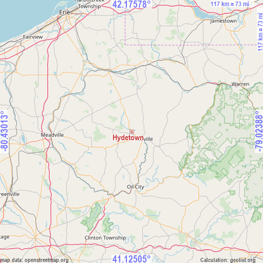
Hydetown GPS coordinates[2]
41° 39' 9.216" North, 79° 43' 37.2" West
| Map corner | latitude | longitude |
|---|---|---|
| Upper-left | 42.17578°, | -80.43013° |
| Center: | 41.65256°, | -79.727° |
| Lower-right: | 41.12505°, | -79.02388° |
| Map W x H: | 116.8×116.8 km | = 72.6×72.6mi |
| max Lat: | 71.29058° ⇑27.6% North |
| Hydetown: | 41.65256° |
| min Lat: | ⇓72.4% South 19.06759° |
| min Long | Hydetown | max Long |
| -171.73463° | -79.727° | -66.98998° |
| W 74.4%⇐ | ⇒25.6% E |
Elevation
Elevation of Hydetown is 384 m = 1260 ft, and this is 89.2 m = 293 ft above average elevation for this country.
| Max E: |
3189 m = 10463 ft | 17.4% |
| Hydetown | 384 m 1260 ft | |
| Avg. | 294.8 m = 967 ft | |
Min E: |
-60 m = -197 ft | 82.6% |
See also: United States elevation on elevation.city.
Geographical zone
Hydetown is located in North temperate zone (between Tropic of Cancer and the Arctic Circle). Distance of this Northern Tropic circle is 2025.4 km =1258.5 mi to South.| Distance of | km | miles | from Hydetown |
|---|---|---|---|
| North Pole | 5375.7 | 3340.3 | to North |
| Arctic Circle | 2769.8 | 1721.1 | to North |
| Tropic Cancer | 2025.4 | 1258.5 | to South |
| Equator | 4631.3 | 2877.8 | to South |


Nearby cities:
15 places around Hydetown: (largest is in red/bold)
• Cambridge Springs
32.1 km =19.9 mi,  301°
301°
• Canadohta Lake
20 km =12.4 mi,  333°
333°
• Cochranton
30.5 km =19 mi,  241°
241°
• Corry
30.6 km =19 mi,  13°
13°
• Franklin
29.6 km =18.4 mi,  197°
197°
• Hasson Heights
23 km =14.3 mi,  169°
169°
• Oil City
24.4 km =15.2 mi,  175°
175°
• Pleasantville
14 km =8.7 mi,  118°
118°
• Seneca
30.5 km =19 mi, 176°
• Sugarcreek
28.7 km =17.8 mi,  206°
206°
• Tidioute
27.1 km =16.8 mi,  82°
82°
• Tionesta
28.5 km =17.7 mi,  127°
127°
• Titusville
5.3 km =3.3 mi, 122°
• Union City
29.2 km =18.1 mi,  340°
340°
• Woodland Heights
27 km =16.8 mi, 177°
Sources, notices
• [Note1] Compared only with cities in United States existing in our database
• [Src1] Map data: © OpenStreetMap contributors (CC-BY-SA)
• [Src2] Other city data from geonames.org with taken over terms of usage.
• [Src3] Geographical zone / Annual Mean Temperature by Robert A. Rohde @ Wikipedia
