Duncannon geodata
Duncannon (Pennsylvania) is a populated place; located in United States in America/New_York (GMT-4) time zone. With population of 1,487 people, there are 13713 cities with bigger population in this country. Compared to other cities in United States, 57.9% of cities are located further ↓South; 80.5% of cities are located further ←West and 68% of cities have higher elevation than Duncannon. Note1
Administrative division(s):
- Level 1: Pennsylvania
- Level 2: Perry County
- Level 3: Borough of Duncannon


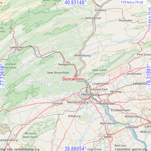
Duncannon GPS coordinates[2]
40° 23' 53.304" North, 77° 1' 22.908" West
| Map corner | latitude | longitude |
|---|---|---|
| Upper-left | 40.93148°, | -77.72616° |
| Center: | 40.39814°, | -77.02303° |
| Lower-right: | 39.86054°, | -76.31991° |
| Map W x H: | 119.1×119.1 km | = 74×74mi |
| max Lat: | 71.29058° ⇑42.1% North |
| Duncannon: | 40.39814° |
| min Lat: | ⇓57.9% South 19.06759° |
| min Long | Duncannon | max Long |
| -171.73463° | -77.02303° | -66.98998° |
| W 80.5%⇐ | ⇒19.5% E |
Elevation
Elevation of Duncannon is 112 m = 367 ft, and this is 182.8 m = 600 ft below average elevation for this country.
| Max E: |
3189 m = 10463 ft | 68% |
| Avg. | 294.8 m = 967 ft | |
| Duncannon | 112 m = 367 ft | |
Min E: |
-60 m = -197 ft | 32% |
See also: United States elevation on elevation.city.
Geographical zone
Duncannon is located in North temperate zone (between Tropic of Cancer and the Arctic Circle). Distance of this Northern Tropic circle is 1885.9 km =1171.8 mi to South.| Distance of | km | miles | from Duncannon |
|---|---|---|---|
| North Pole | 5515.2 | 3427 | to North |
| Arctic Circle | 2909.3 | 1807.8 | to North |
| Tropic Cancer | 1885.9 | 1171.8 | to South |
| Equator | 4491.9 | 2791.1 | to South |


Nearby cities:
15 places around Duncannon: (largest is in red/bold)
• Camp Hill
19.7 km =12.2 mi,  153°
153°
• Dauphin
8.5 km =5.3 mi,  113°
113°
• Enola
14.2 km =8.8 mi, 147°
• Halifax
11 km =6.8 mi,  44°
44°
• Harrisburg
18.2 km =11.3 mi,  139°
139°
• Lawrence Park
19.7 km =12.2 mi, 107°
• Lenkerville
16 km =9.9 mi,  19°
19°
• Liverpool
19.9 km =12.4 mi,  8°
8°
• Marysville
10 km =6.2 mi,  128°
128°
• Matamoras
8.9 km =5.5 mi,  58°
58°
• Millersburg
16.6 km =10.3 mi, 18°
• New Bloomfield
14 km =8.7 mi,  279°
279°
• Newport
12.7 km =7.9 mi,  314°
314°
• West Fairview
16.4 km =10.2 mi, 146°
• Wormleysburg
17.7 km =11 mi, 148°
Sources, notices
• [Note1] Compared only with cities in United States existing in our database
• [Src1] Map data: © OpenStreetMap contributors (CC-BY-SA)
• [Src2] Other city data from geonames.org with taken over terms of usage.
• [Src3] Geographical zone / Annual Mean Temperature by Robert A. Rohde @ Wikipedia
