Hellertown geodata
Hellertown (Pennsylvania) is a populated place; located in United States in America/New_York (GMT-4) time zone. With population of 5,824 people, there are 6522 cities with bigger population in this country. Compared to other cities in United States, 59.8% of cities are located further ↓South; 86.2% of cities are located further ←West and 72.3% of cities have higher elevation than Hellertown. Note1
Administrative division(s):
- Level 1: Pennsylvania
- Level 2: Northampton County
- Level 3: Borough of Hellertown


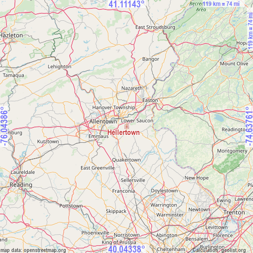
Hellertown GPS coordinates[2]
40° 34' 46.344" North, 75° 20' 26.628" West
| Map corner | latitude | longitude |
|---|---|---|
| Upper-left | 41.11143°, | -76.04386° |
| Center: | 40.57954°, | -75.34073° |
| Lower-right: | 40.04338°, | -74.63761° |
| Map W x H: | 118.8×118.8 km | = 73.8×73.8mi |
| max Lat: | 71.29058° ⇑40.2% North |
| Hellertown: | 40.57954° |
| min Lat: | ⇓59.8% South 19.06759° |
| min Long | Hellertown | max Long |
| -171.73463° | -75.34073° | -66.98998° |
| W 86.2%⇐ | ⇒13.8% E |
Elevation
Elevation of Hellertown is 87 m = 285 ft, and this is 207.8 m = 682 ft below average elevation for this country.
| Max E: |
3189 m = 10463 ft | 72.3% |
| Avg. | 294.8 m = 967 ft | |
| Hellertown | 87 m = 285 ft | |
Min E: |
-60 m = -197 ft | 27.7% |
See also: United States elevation on elevation.city.
Geographical zone
Hellertown is located in North temperate zone (between Tropic of Cancer and the Arctic Circle). Distance of this Northern Tropic circle is 1906.1 km =1184.4 mi to South.| Distance of | km | miles | from Hellertown |
|---|---|---|---|
| North Pole | 5495 | 3414.4 | to North |
| Arctic Circle | 2889.2 | 1795.3 | to North |
| Tropic Cancer | 1906.1 | 1184.4 | to South |
| Equator | 4512 | 2803.6 | to South |


Nearby cities:
15 places around Hellertown: (largest is in red/bold)
• Allentown
13 km =8.1 mi,  284°
284°
• Bethlehem
5.7 km =3.5 mi,  334°
334°
• Catasauqua
14.1 km =8.8 mi,  306°
306°
• Coopersburg
8.7 km =5.4 mi,  209°
209°
• Emmaus
13.9 km =8.6 mi,  251°
251°
• Fountain Hill
5.2 km =3.2 mi,  297°
297°
• Freemansburg
5.2 km =3.2 mi,  355°
355°
• Fullerton
12.6 km =7.8 mi, 297°
• Middletown
7.2 km =4.5 mi,  5°
5°
• Old Orchard
10.9 km =6.8 mi,  37°
37°
• Palmer Heights
13.7 km =8.5 mi,  28°
28°
• Raubsville
13.9 km =8.6 mi,  63°
63°
• Richlandtown
12.3 km =7.6 mi,  171°
171°
• Riegelsville
12.4 km =7.7 mi,  82°
82°
• West Easton
14.1 km =8.8 mi, 38°
Sources, notices
• [Note1] Compared only with cities in United States existing in our database
• [Src1] Map data: © OpenStreetMap contributors (CC-BY-SA)
• [Src2] Other city data from geonames.org with taken over terms of usage.
• [Src3] Geographical zone / Annual Mean Temperature by Robert A. Rohde @ Wikipedia
