Kersey geodata
Kersey (Pennsylvania) is a populated place; located in United States in America/New_York (GMT-4) time zone. With population of 937 people, there are 16738 cities with bigger population in this country. Compared to other cities in United States, 69.4% of cities are located further ↓South; 76.8% of cities are located further ←West and 89.7% of cities have lower elevation than Kersey. Note1


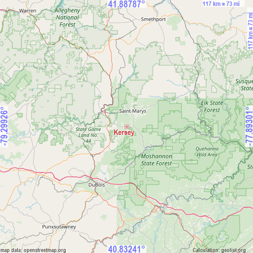
Kersey GPS coordinates[2]
41° 21' 44.208" North, 78° 35' 46.068" West
| Map corner | latitude | longitude |
|---|---|---|
| Upper-left | 41.88787°, | -79.29926° |
| Center: | 41.36228°, | -78.59613° |
| Lower-right: | 40.83241°, | -77.89301° |
| Map W x H: | 117.4×117.4 km | = 72.9×72.9mi |
| max Lat: | 71.29058° ⇑30.6% North |
| Kersey: | 41.36228° |
| min Lat: | ⇓69.4% South 19.06759° |
| min Long | Kersey | max Long |
| -171.73463° | -78.59613° | -66.98998° |
| W 76.8%⇐ | ⇒23.2% E |
Elevation
Elevation of Kersey is 603 m = 1978 ft, and this is 308.2 m = 1011 ft above average elevation for this country.
| Max E: |
3189 m = 10463 ft | 10.3% |
| Kersey | 603 m 1978 ft | |
| Avg. | 294.8 m = 967 ft | |
Min E: |
-60 m = -197 ft | 89.7% |
See also: United States elevation on elevation.city.
Geographical zone
Kersey is located in North temperate zone (between Tropic of Cancer and the Arctic Circle). Distance of this Northern Tropic circle is 1993.1 km =1238.5 mi to South.| Distance of | km | miles | from Kersey |
|---|---|---|---|
| North Pole | 5408 | 3360.4 | to North |
| Arctic Circle | 2802.1 | 1741.1 | to North |
| Tropic Cancer | 1993.1 | 1238.5 | to South |
| Equator | 4599.1 | 2857.7 | to South |


Nearby cities:
15 places around Kersey: (largest is in red/bold)
• Brockway
21.1 km =13.1 mi,  233°
233°
• Clearfield
39.5 km =24.5 mi,  160°
160°
• DuBois
30.3 km =18.8 mi,  206°
206°
• Emporium
34.3 km =21.3 mi,  61°
61°
• Falls Creek
29.8 km =18.5 mi,  215°
215°
• Johnsonburg
15.7 km =9.8 mi,  335°
335°
• Kane
37.9 km =23.5 mi,  331°
331°
• Oklahoma
29.9 km =18.6 mi,  202°
202°
• Plymptonville
37.4 km =23.2 mi, 160°
• Reynoldsville
38.3 km =23.8 mi, 219°
• Ridgway
12.8 km =8 mi,  300°
300°
• Saint Marys
7.9 km =4.9 mi,  21°
21°
• Sandy
31.9 km =19.8 mi, 207°
• Treasure Lake
23.3 km =14.5 mi, 205°
• Weedville
12.9 km =8 mi,  137°
137°
Sources, notices
• [Note1] Compared only with cities in United States existing in our database
• [Src1] Map data: © OpenStreetMap contributors (CC-BY-SA)
• [Src2] Other city data from geonames.org with taken over terms of usage.
• [Src3] Geographical zone / Annual Mean Temperature by Robert A. Rohde @ Wikipedia
