Lewis Run geodata
Lewis Run (Pennsylvania) is a populated place; located in United States in America/New_York (GMT-4) time zone. With population of 596 people, there are 19749 cities with bigger population in this country. Compared to other cities in United States, 74.5% of cities are located further ↓South; 76.6% of cities are located further ←West and 87.2% of cities have lower elevation than Lewis Run. Note1
Administrative division(s):
- Level 1: Pennsylvania
- Level 2: McKean County
- Level 3: Borough of Lewis Run


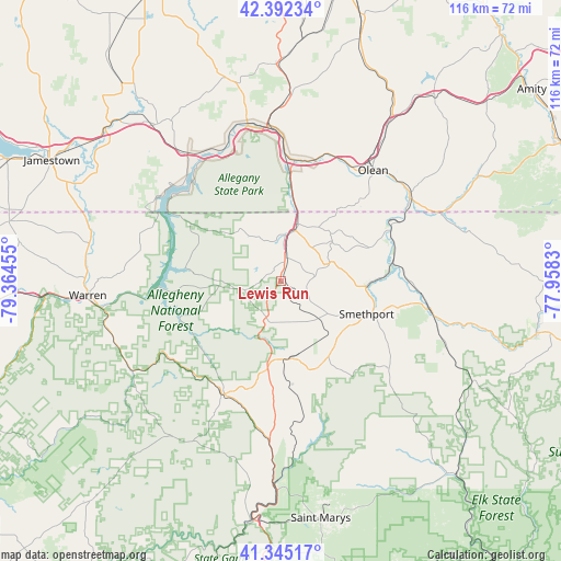
Lewis Run GPS coordinates[2]
41° 52' 15.24" North, 78° 39' 41.112" West
| Map corner | latitude | longitude |
|---|---|---|
| Upper-left | 42.39234°, | -79.36455° |
| Center: | 41.8709°, | -78.66142° |
| Lower-right: | 41.34517°, | -77.9583° |
| Map W x H: | 116.4×116.4 km | = 72.3×72.3mi |
| max Lat: | 71.29058° ⇑25.5% North |
| Lewis Run: | 41.8709° |
| min Lat: | ⇓74.5% South 19.06759° |
| min Long | Lewis Run | max Long |
| -171.73463° | -78.66142° | -66.98998° |
| W 76.6%⇐ | ⇒23.4% E |
Elevation
Elevation of Lewis Run is 474 m = 1555 ft, and this is 179.2 m = 588 ft above average elevation for this country.
| Max E: |
3189 m = 10463 ft | 12.8% |
| Lewis Run | 474 m 1555 ft | |
| Avg. | 294.8 m = 967 ft | |
Min E: |
-60 m = -197 ft | 87.2% |
See also: United States elevation on elevation.city.
Geographical zone
Lewis Run is located in North temperate zone (between Tropic of Cancer and the Arctic Circle). Distance of this Northern Tropic circle is 2049.7 km =1273.6 mi to South.| Distance of | km | miles | from Lewis Run |
|---|---|---|---|
| North Pole | 5351.5 | 3325.3 | to North |
| Arctic Circle | 2745.6 | 1706 | to North |
| Tropic Cancer | 2049.7 | 1273.6 | to South |
| Equator | 4655.6 | 2892.9 | to South |


Nearby cities:
15 places around Lewis Run: (largest is in red/bold)
• Allegany
28 km =17.4 mi,  29°
29°
• Bradford
9.6 km =6 mi,  8°
8°
• Eldred
24.8 km =15.4 mi,  67°
67°
• Foster Brook
12.1 km =7.5 mi,  17°
17°
• Kane
26.3 km =16.3 mi,  208°
208°
• Mount Jewett
16.3 km =10.1 mi,  173°
173°
• Olean
29.9 km =18.6 mi,  39°
39°
• Port Allegany
32.3 km =20.1 mi,  101°
101°
• Portville
32.4 km =20.1 mi,  54°
54°
• Saint Bonaventure
27.9 km =17.3 mi, 33°
• Salamanca
32.2 km =20 mi,  352°
352°
• Sheffield
36.2 km =22.5 mi,  239°
239°
• Smethport
19.1 km =11.9 mi,  110°
110°
• Weston Mills
33 km =20.5 mi, 46°
• Westons Mills
31.7 km =19.7 mi, 47°
Sources, notices
• [Note1] Compared only with cities in United States existing in our database
• [Src1] Map data: © OpenStreetMap contributors (CC-BY-SA)
• [Src2] Other city data from geonames.org with taken over terms of usage.
• [Src3] Geographical zone / Annual Mean Temperature by Robert A. Rohde @ Wikipedia
