Linglestown geodata
Linglestown (Pennsylvania) is a populated place; located in United States in America/New_York (GMT-4) time zone. With population of 6,334 people, there are 6198 cities with bigger population in this country. Compared to other cities in United States, 57.1% of cities are located further ↓South; 81.5% of cities are located further ←West and 57.7% of cities have higher elevation than Linglestown. Note1
Administrative division(s):
- Level 1: Pennsylvania
- Level 2: Dauphin County
- Level 3: Township of Lower Paxton


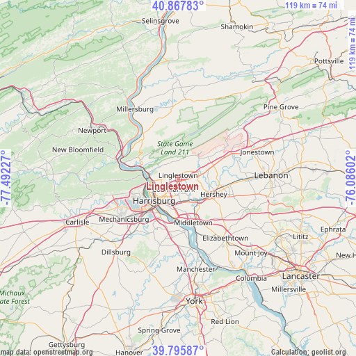
Linglestown GPS coordinates[2]
40° 20' 2.328" North, 76° 47' 20.904" West
| Map corner | latitude | longitude |
|---|---|---|
| Upper-left | 40.86783°, | -77.49227° |
| Center: | 40.33398°, | -76.78914° |
| Lower-right: | 39.79587°, | -76.08602° |
| Map W x H: | 119.2×119.2 km | = 74.1×74.1mi |
| max Lat: | 71.29058° ⇑42.9% North |
| Linglestown: | 40.33398° |
| min Lat: | ⇓57.1% South 19.06759° |
| min Long | Linglestown | max Long |
| -171.73463° | -76.78914° | -66.98998° |
| W 81.5%⇐ | ⇒18.5% E |
Elevation
Elevation of Linglestown is 167 m = 548 ft, and this is 127.8 m = 419 ft below average elevation for this country.
| Max E: |
3189 m = 10463 ft | 57.7% |
| Avg. | 294.8 m = 967 ft | |
| Linglestown | 167 m = 548 ft | |
Min E: |
-60 m = -197 ft | 42.3% |
See also: United States elevation on elevation.city.
Geographical zone
Linglestown is located in North temperate zone (between Tropic of Cancer and the Arctic Circle). Distance of this Northern Tropic circle is 1878.8 km =1167.4 mi to South.| Distance of | km | miles | from Linglestown |
|---|---|---|---|
| North Pole | 5522.3 | 3431.4 | to North |
| Arctic Circle | 2916.5 | 1812.2 | to North |
| Tropic Cancer | 1878.8 | 1167.4 | to South |
| Equator | 4484.7 | 2786.7 | to South |


Nearby cities:
15 places around Linglestown: (largest is in red/bold)
• Bressler
11.9 km =7.4 mi,  192°
192°
• Colonial Park
4.1 km =2.5 mi,  205°
205°
• Enhaut
11.8 km =7.3 mi,  195°
195°
• Harrisburg
10.5 km =6.5 mi,  230°
230°
• Hummelstown
10.3 km =6.4 mi,  138°
138°
• Lawnton
8.5 km =5.3 mi, 188°
• Lawrence Park
1.6 km =1 mi,  322°
322°
• Oberlin
10.5 km =6.5 mi, 191°
• Paxtang
9.1 km =5.7 mi, 203°
• Paxtonia
1.9 km =1.2 mi, 193°
• Penbrook
8.2 km =5.1 mi,  217°
217°
• Progress
6.5 km =4 mi, 213°
• Rutherford
7.4 km =4.6 mi,  166°
166°
• Skyline View
5.4 km =3.4 mi,  83°
83°
• Steelton
11.8 km =7.3 mi, 201°
Sources, notices
• [Note1] Compared only with cities in United States existing in our database
• [Src1] Map data: © OpenStreetMap contributors (CC-BY-SA)
• [Src2] Other city data from geonames.org with taken over terms of usage.
• [Src3] Geographical zone / Annual Mean Temperature by Robert A. Rohde @ Wikipedia
