Patterson Heights geodata
Patterson Heights (Pennsylvania) is a populated place; located in United States in America/New_York (GMT-4) time zone. With population of 617 people, there are 19506 cities with bigger population in this country. Compared to other cities in United States, 62.2% of cities are located further ↓South; 71.5% of cities are located further ←West and 76.5% of cities have lower elevation than Patterson Heights. Note1
Administrative division(s):
- Level 1: Pennsylvania
- Level 2: Beaver County
- Level 3: Borough of Patterson Heights


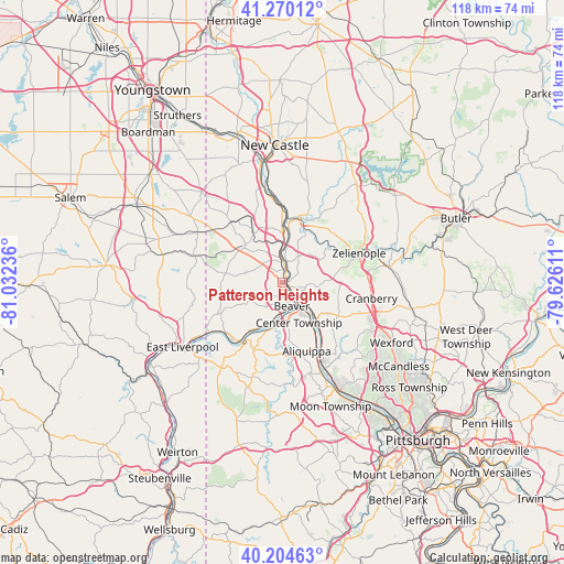
Patterson Heights GPS coordinates[2]
40° 44' 22.236" North, 80° 19' 45.228" West
| Map corner | latitude | longitude |
|---|---|---|
| Upper-left | 41.27012°, | -81.03236° |
| Center: | 40.73951°, | -80.32923° |
| Lower-right: | 40.20463°, | -79.62611° |
| Map W x H: | 118.5×118.5 km | = 73.6×73.6mi |
| max Lat: | 71.29058° ⇑37.8% North |
| Patterson Heights: | 40.73951° |
| min Lat: | ⇓62.2% South 19.06759° |
| min Long | Patterson Heigh | max Long |
| -171.73463° | -80.32923° | -66.98998° |
| W 71.5%⇐ | ⇒28.5% E |
Elevation
Elevation of Patterson Heights is 324 m = 1063 ft, and this is 29.2 m = 96 ft above average elevation for this country.
| Max E: |
3189 m = 10463 ft | 23.5% |
| Patterson Heights | 324 m 1063 ft | |
| Avg. | 294.8 m = 967 ft | |
Min E: |
-60 m = -197 ft | 76.5% |
See also: United States elevation on elevation.city.
Geographical zone
Patterson Heights is located in North temperate zone (between Tropic of Cancer and the Arctic Circle). Distance of this Northern Tropic circle is 1923.9 km =1195.5 mi to South.| Distance of | km | miles | from Patterson Heights |
|---|---|---|---|
| North Pole | 5477.3 | 3403.4 | to North |
| Arctic Circle | 2871.4 | 1784.2 | to North |
| Tropic Cancer | 1923.9 | 1195.5 | to South |
| Equator | 4529.8 | 2814.7 | to South |


Nearby cities:
15 places around Patterson Heights: (largest is in red/bold)
• Aliquippa
13.7 km =8.5 mi,  146°
146°
• Beaver
5.3 km =3.3 mi,  157°
157°
• Beaver Falls
1.6 km =1 mi,  31°
31°
• Big Beaver
9.9 km =6.2 mi,  343°
343°
• Bridgewater
4.5 km =2.8 mi, 148°
• Conway
11.7 km =7.3 mi,  139°
139°
• East Rochester
6.8 km =4.2 mi,  130°
130°
• Ellwood City
14.1 km =8.8 mi,  14°
14°
• Freedom
8.9 km =5.5 mi, 132°
• Industry
12.9 km =8 mi,  214°
214°
• Koppel
10.5 km =6.5 mi,  3°
3°
• Monaca
7.6 km =4.7 mi, 140°
• New Brighton
1.9 km =1.2 mi,  122°
122°
• Rochester
5.5 km =3.4 mi, 138°
• West Mayfield
4.6 km =2.9 mi,  350°
350°
Sources, notices
• [Note1] Compared only with cities in United States existing in our database
• [Src1] Map data: © OpenStreetMap contributors (CC-BY-SA)
• [Src2] Other city data from geonames.org with taken over terms of usage.
• [Src3] Geographical zone / Annual Mean Temperature by Robert A. Rohde @ Wikipedia
