Bernville geodata
Bernville (Pennsylvania) is a populated place; located in United States in America/New_York (GMT-4) time zone. With population of 951 people, there are 16634 cities with bigger population in this country. Compared to other cities in United States, 58.3% of cities are located further ↓South; 83.7% of cities are located further ←West and 70.6% of cities have higher elevation than Bernville. Note1
Administrative division(s):
- Level 1: Pennsylvania
- Level 2: Berks County
- Level 3: Borough of Bernville


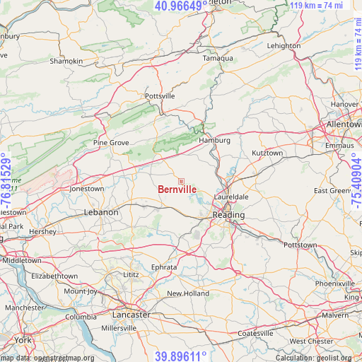
Bernville GPS coordinates[2]
40° 26' 0.348" North, 76° 6' 43.776" West
| Map corner | latitude | longitude |
|---|---|---|
| Upper-left | 40.96649°, | -76.81529° |
| Center: | 40.43343°, | -76.11216° |
| Lower-right: | 39.89611°, | -75.40904° |
| Map W x H: | 119×119 km | = 73.9×73.9mi |
| max Lat: | 71.29058° ⇑41.7% North |
| Bernville: | 40.43343° |
| min Lat: | ⇓58.3% South 19.06759° |
| min Long | Bernville | max Long |
| -171.73463° | -76.11216° | -66.98998° |
| W 83.7%⇐ | ⇒16.3% E |
Elevation
Elevation of Bernville is 97 m = 318 ft, and this is 197.8 m = 649 ft below average elevation for this country.
| Max E: |
3189 m = 10463 ft | 70.6% |
| Avg. | 294.8 m = 967 ft | |
| Bernville | 97 m = 318 ft | |
Min E: |
-60 m = -197 ft | 29.4% |
See also: United States elevation on elevation.city.
Geographical zone
Bernville is located in North temperate zone (between Tropic of Cancer and the Arctic Circle). Distance of this Northern Tropic circle is 1889.9 km =1174.3 mi to South.| Distance of | km | miles | from Bernville |
|---|---|---|---|
| North Pole | 5511.3 | 3424.6 | to North |
| Arctic Circle | 2905.4 | 1805.3 | to North |
| Tropic Cancer | 1889.9 | 1174.3 | to South |
| Equator | 4495.8 | 2793.6 | to South |


Nearby cities:
15 places around Bernville: (largest is in red/bold)
• Colony Park
14.6 km =9.1 mi,  131°
131°
• Dauberville
11.5 km =7.1 mi,  73°
73°
• Fox Chase
13.4 km =8.3 mi,  108°
108°
• Leesport
12.4 km =7.7 mi,  83°
83°
• Newmanstown
12.7 km =7.9 mi,  222°
222°
• Richland
14.9 km =9.3 mi,  236°
236°
• River View Park
13.8 km =8.6 mi, 109°
• Robesonia
9.3 km =5.8 mi,  191°
191°
• Shoemakersville
14.2 km =8.8 mi,  58°
58°
• Sinking Spring
14.6 km =9.1 mi,  144°
144°
• Spring Ridge
13.7 km =8.5 mi, 130°
• Stouchsburg
11.8 km =7.3 mi, 239°
• Wernersville
11.8 km =7.3 mi,  166°
166°
• Whitfield
14.1 km =8.8 mi, 140°
• Womelsdorf
10 km =6.2 mi, 217°
Sources, notices
• [Note1] Compared only with cities in United States existing in our database
• [Src1] Map data: © OpenStreetMap contributors (CC-BY-SA)
• [Src2] Other city data from geonames.org with taken over terms of usage.
• [Src3] Geographical zone / Annual Mean Temperature by Robert A. Rohde @ Wikipedia
