Sankertown geodata
Sankertown (Pennsylvania) is a populated place; located in United States in America/New_York (GMT-4) time zone. With population of 650 people, there are 19178 cities with bigger population in this country. Compared to other cities in United States, 58.6% of cities are located further ↓South; 76.8% of cities are located further ←West and 90.2% of cities have lower elevation than Sankertown. Note1
Administrative division(s):
- Level 1: Pennsylvania
- Level 2: Cambria County
- Level 3: Borough of Sankertown


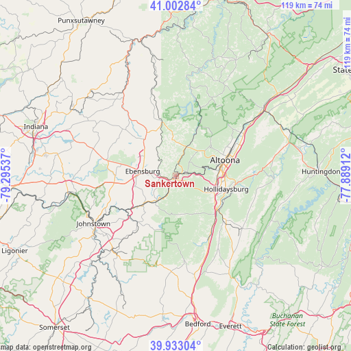
Sankertown GPS coordinates[2]
40° 28' 12.252" North, 78° 35' 32.064" West
| Map corner | latitude | longitude |
|---|---|---|
| Upper-left | 41.00284°, | -79.29537° |
| Center: | 40.47007°, | -78.59224° |
| Lower-right: | 39.93304°, | -77.88912° |
| Map W x H: | 119×118.9 km | = 73.9×73.9mi |
| max Lat: | 71.29058° ⇑41.4% North |
| Sankertown: | 40.47007° |
| min Lat: | ⇓58.6% South 19.06759° |
| min Long | Sankertown | max Long |
| -171.73463° | -78.59224° | -66.98998° |
| W 76.8%⇐ | ⇒23.2% E |
Elevation
Elevation of Sankertown is 634 m = 2080 ft, and this is 339.2 m = 1113 ft above average elevation for this country.
| Max E: |
3189 m = 10463 ft | 9.8% |
| Sankertown | 634 m 2080 ft | |
| Avg. | 294.8 m = 967 ft | |
Min E: |
-60 m = -197 ft | 90.2% |
See also: United States elevation on elevation.city.
Geographical zone
Sankertown is located in North temperate zone (between Tropic of Cancer and the Arctic Circle). Distance of this Northern Tropic circle is 1893.9 km =1176.8 mi to South.| Distance of | km | miles | from Sankertown |
|---|---|---|---|
| North Pole | 5507.2 | 3422 | to North |
| Arctic Circle | 2901.3 | 1802.8 | to North |
| Tropic Cancer | 1893.9 | 1176.8 | to South |
| Equator | 4499.8 | 2796 | to South |


Nearby cities:
15 places around Sankertown: (largest is in red/bold)
• Altoona
17.6 km =10.9 mi,  72°
72°
• Carrolltown
17.7 km =11 mi,  326°
326°
• Colver
18.4 km =11.4 mi,  296°
296°
• Cresson
1.1 km =0.7 mi,  177°
177°
• Duncansville
14.4 km =8.9 mi,  111°
111°
• Ebensburg
11.3 km =7 mi,  278°
278°
• Foot of Ten
13.1 km =8.1 mi,  117°
117°
• Gallitzin
3.7 km =2.3 mi, 68°
• Hollidaysburg
17.9 km =11.1 mi, 105°
• Lakemont
17.2 km =10.7 mi,  88°
88°
• Lilly
5.4 km =3.4 mi,  205°
205°
• Loretto
4.9 km =3 mi,  318°
318°
• Portage
11.3 km =7 mi,  216°
216°
• Revloc
14.8 km =9.2 mi, 279°
• Spring Hill
12.3 km =7.6 mi, 212°
Sources, notices
• [Note1] Compared only with cities in United States existing in our database
• [Src1] Map data: © OpenStreetMap contributors (CC-BY-SA)
• [Src2] Other city data from geonames.org with taken over terms of usage.
• [Src3] Geographical zone / Annual Mean Temperature by Robert A. Rohde @ Wikipedia
