Altoona geodata
Altoona (Pennsylvania) is a populated place; located in United States in America/New_York (GMT-4) time zone. With population of 45,344 people, there are 1053 cities with bigger population in this country. Compared to other cities in United States, 59.1% of cities are located further ↓South; 77.1% of cities are located further ←West and 80.5% of cities have lower elevation than Altoona. Note1


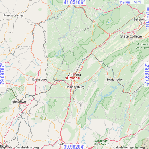
Altoona GPS coordinates[2]
40° 31' 7.248" North, 78° 23' 41.064" West
| Map corner | latitude | longitude |
|---|---|---|
| Upper-left | 41.05106°, | -79.09787° |
| Center: | 40.51868°, | -78.39474° |
| Lower-right: | 39.98204°, | -77.69162° |
| Map W x H: | 118.9×118.9 km | = 73.9×73.9mi |
| max Lat: | 71.29058° ⇑40.9% North |
| Altoona: | 40.51868° |
| min Lat: | ⇓59.1% South 19.06759° |
| min Long | Altoona | max Long |
| -171.73463° | -78.39474° | -66.98998° |
| W 77.1%⇐ | ⇒22.9% E |
Elevation
Elevation of Altoona is 359 m = 1178 ft, and this is 64.2 m = 211 ft above average elevation for this country.
| Max E: |
3189 m = 10463 ft | 19.5% |
| Altoona | 359 m 1178 ft | |
| Avg. | 294.8 m = 967 ft | |
Min E: |
-60 m = -197 ft | 80.5% |
See also: Altoona elevation on elevation.city.
Geographical zone
Altoona is located in North temperate zone (between Tropic of Cancer and the Arctic Circle). Distance of this Northern Tropic circle is 1899.3 km =1180.2 mi to South.| Distance of | km | miles | from Altoona |
|---|---|---|---|
| North Pole | 5501.8 | 3418.7 | to North |
| Arctic Circle | 2895.9 | 1799.4 | to North |
| Tropic Cancer | 1899.3 | 1180.2 | to South |
| Equator | 4505.3 | 2799.5 | to South |


Nearby cities:
15 places around Altoona: (largest is in red/bold)
• Bellwood
11.1 km =6.9 mi,  32°
32°
• Cresson
17.9 km =11.1 mi,  248°
248°
• Duncansville
11.1 km =6.9 mi,  197°
197°
• East Freedom
18.2 km =11.3 mi,  189°
189°
• Foot of Ten
12.5 km =7.8 mi, 204°
• Gallitzin
13.9 km =8.6 mi, 253°
• Grazierville
18.6 km =11.6 mi,  36°
36°
• Greenwood
3.7 km =2.3 mi,  58°
58°
• Hollidaysburg
10.2 km =6.3 mi,  177°
177°
• Lakemont
5.1 km =3.2 mi,  173°
173°
• Loretto
20 km =12.4 mi,  265°
265°
• Roaring Spring
20.3 km =12.6 mi, 179°
• Sankertown
17.6 km =10.9 mi, 252°
• Tipton
15.5 km =9.6 mi, 32°
• Williamsburg
17.7 km =11 mi,  110°
110°
Sources, notices
• [Note1] Compared only with cities in United States existing in our database
• [Src1] Map data: © OpenStreetMap contributors (CC-BY-SA)
• [Src2] Other city data from geonames.org with taken over terms of usage.
• [Src3] Geographical zone / Annual Mean Temperature by Robert A. Rohde @ Wikipedia
