Shoemakersville geodata
Shoemakersville (Pennsylvania) is a populated place; located in United States in America/New_York (GMT-4) time zone. With population of 1,369 people, there are 14269 cities with bigger population in this country. Compared to other cities in United States, 58.9% of cities are located further ↓South; 84.1% of cities are located further ←West and 68.6% of cities have higher elevation than Shoemakersville. Note1
Administrative division(s):
- Level 1: Pennsylvania
- Level 2: Berks County
- Level 3: Borough of Shoemakersville


Shoemakersville GPS coordinates[2]
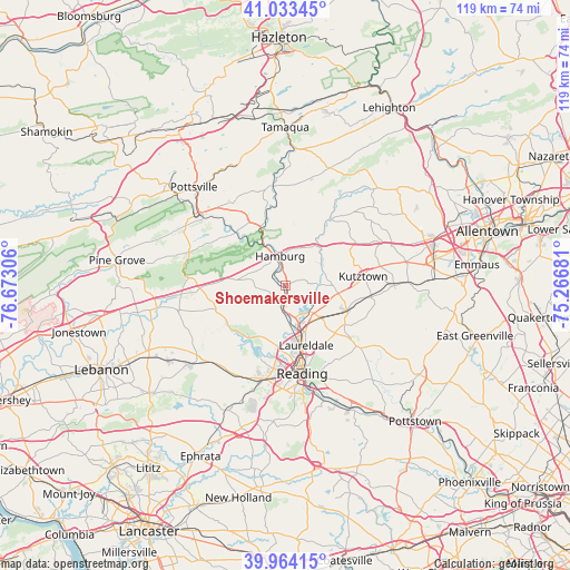
40° 30' 3.348" North, 75° 58' 11.748" West
| Map corner | latitude | longitude |
|---|---|---|
| Upper-left | 41.03345°, | -76.67306° |
| Center: | 40.50093°, | -75.96993° |
| Lower-right: | 39.96415°, | -75.26681° |
| Map W x H: | 118.9×118.9 km | = 73.9×73.9mi |
| max Lat: | 71.29058° ⇑41.1% North |
| Shoemakersville: | 40.50093° |
| min Lat: | ⇓58.9% South 19.06759° |
| min Long | Shoemakersville | max Long |
| -171.73463° | -75.96993° | -66.98998° |
| W 84.1%⇐ | ⇒15.9% E |
Elevation
Elevation of Shoemakersville is 109 m = 358 ft, and this is 185.8 m = 610 ft below average elevation for this country.
| Max E: |
3189 m = 10463 ft | 68.6% |
| Avg. | 294.8 m = 967 ft | |
| Shoemakersville | 109 m = 358 ft | |
Min E: |
-60 m = -197 ft | 31.4% |
See also: United States elevation on elevation.city.
Geographical zone
Shoemakersville is located in North temperate zone (between Tropic of Cancer and the Arctic Circle). Distance of this Northern Tropic circle is 1897.4 km =1179 mi to South.| Distance of | km | miles | from Shoemakersville |
|---|---|---|---|
| North Pole | 5503.8 | 3419.9 | to North |
| Arctic Circle | 2897.9 | 1800.7 | to North |
| Tropic Cancer | 1897.4 | 1179 | to South |
| Equator | 4503.3 | 2798.2 | to South |


Nearby cities:
15 places around Shoemakersville: (largest is in red/bold)
• Bernville
14.2 km =8.8 mi,  238°
238°
• Blandon
9.7 km =6 mi,  133°
133°
• Dauberville
4.3 km =2.7 mi,  193°
193°
• Edenburg
7.3 km =4.5 mi,  6°
6°
• Fleetwood
13.9 km =8.6 mi,  112°
112°
• Fox Chase
11.7 km =7.3 mi,  176°
176°
• Hamburg
6.2 km =3.9 mi,  350°
350°
• Hyde Park
14.3 km =8.9 mi,  164°
164°
• Laureldale
13.3 km =8.3 mi, 160°
• Leesport
6 km =3.7 mi, 177°
• Muhlenberg Park
13.1 km =8.1 mi,  169°
169°
• River View Park
12.1 km =7.5 mi, 175°
• South Temple
12.7 km =7.9 mi,  152°
152°
• Temple
11 km =6.8 mi, 158°
• West Hamburg
5.9 km =3.7 mi,  332°
332°
Sources, notices
• [Note1] Compared only with cities in United States existing in our database
• [Src1] Map data: © OpenStreetMap contributors (CC-BY-SA)
• [Src2] Other city data from geonames.org with taken over terms of usage.
• [Src3] Geographical zone / Annual Mean Temperature by Robert A. Rohde @ Wikipedia
