Slippery Rock geodata
Slippery Rock (Pennsylvania) is a populated place; located in United States in America/New_York (GMT-4) time zone. With population of 3,613 people, there are 8707 cities with bigger population in this country. Compared to other cities in United States, 66.6% of cities are located further ↓South; 73.1% of cities are located further ←West and 83.4% of cities have lower elevation than Slippery Rock. Note1
Administrative division(s):
- Level 1: Pennsylvania
- Level 2: Butler County
- Level 3: Borough of Slippery Rock


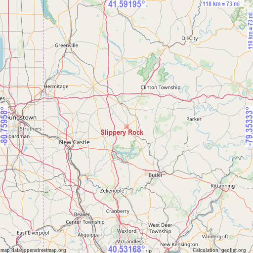
Slippery Rock GPS coordinates[2]
41° 3' 50.22" North, 80° 3' 23.22" West
| Map corner | latitude | longitude |
|---|---|---|
| Upper-left | 41.59195°, | -80.75958° |
| Center: | 41.06395°, | -80.05645° |
| Lower-right: | 40.53168°, | -79.35333° |
| Map W x H: | 117.9×117.9 km | = 73.3×73.3mi |
| max Lat: | 71.29058° ⇑33.4% North |
| Slippery Rock: | 41.06395° |
| min Lat: | ⇓66.6% South 19.06759° |
| min Long | Slippery Rock | max Long |
| -171.73463° | -80.05645° | -66.98998° |
| W 73.1%⇐ | ⇒26.9% E |
Elevation
Elevation of Slippery Rock is 396 m = 1299 ft, and this is 101.2 m = 332 ft above average elevation for this country.
| Max E: |
3189 m = 10463 ft | 16.6% |
| Slippery Rock | 396 m 1299 ft | |
| Avg. | 294.8 m = 967 ft | |
Min E: |
-60 m = -197 ft | 83.4% |
See also: United States elevation on elevation.city.
Geographical zone
Slippery Rock is located in North temperate zone (between Tropic of Cancer and the Arctic Circle). Distance of this Northern Tropic circle is 1960 km =1217.9 mi to South.| Distance of | km | miles | from Slippery Rock |
|---|---|---|---|
| North Pole | 5441.2 | 3381 | to North |
| Arctic Circle | 2835.3 | 1761.8 | to North |
| Tropic Cancer | 1960 | 1217.9 | to South |
| Equator | 4565.9 | 2837.1 | to South |


Nearby cities:
15 places around Slippery Rock: (largest is in red/bold)
• Butler
26.3 km =16.3 mi,  149°
149°
• East Butler
27.2 km =16.9 mi,  139°
139°
• Grove City
10.8 km =6.7 mi,  345°
345°
• Harrisville
9 km =5.6 mi,  26°
26°
• Homeacre-Lyndora
24.2 km =15 mi, 151°
• Lake Arthur Estates
14.1 km =8.8 mi,  215°
215°
• Mercer
23.8 km =14.8 mi,  319°
319°
• Meridian
25.2 km =15.7 mi,  161°
161°
• New Castle
25.3 km =15.7 mi,  254°
254°
• New Castle Northwest
25.6 km =15.9 mi,  259°
259°
• New Wilmington
24.1 km =15 mi,  285°
285°
• Prospect
17.7 km =11 mi,  177°
177°
• Shanor-Northvue
20.8 km =12.9 mi, 145°
• South New Castle
26 km =16.2 mi, 248°
• Unionville
15.8 km =9.8 mi, 149°
Sources, notices
• [Note1] Compared only with cities in United States existing in our database
• [Src1] Map data: © OpenStreetMap contributors (CC-BY-SA)
• [Src2] Other city data from geonames.org with taken over terms of usage.
• [Src3] Geographical zone / Annual Mean Temperature by Robert A. Rohde @ Wikipedia
