Wesleyville geodata
Wesleyville (Pennsylvania) is a populated place; located in United States in America/New_York (GMT-4) time zone. With population of 3,226 people, there are 9265 cities with bigger population in this country. Compared to other cities in United States, 76.9% of cities are located further ↓South; 73.2% of cities are located further ←West and 55.6% of cities have lower elevation than Wesleyville. Note1
Administrative division(s):
- Level 1: Pennsylvania
- Level 2: Erie County
- Level 3: Borough of Wesleyville


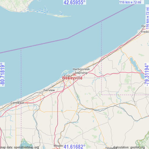
Wesleyville GPS coordinates[2]
42° 8' 25.188" North, 80° 0' 54.216" West
| Map corner | latitude | longitude |
|---|---|---|
| Upper-left | 42.65955°, | -80.71819° |
| Center: | 42.14033°, | -80.01506° |
| Lower-right: | 41.61682°, | -79.31194° |
| Map W x H: | 115.9×115.9 km | = 72×72mi |
| max Lat: | 71.29058° ⇑23.1% North |
| Wesleyville: | 42.14033° |
| min Lat: | ⇓76.9% South 19.06759° |
| min Long | Wesleyville | max Long |
| -171.73463° | -80.01506° | -66.98998° |
| W 73.2%⇐ | ⇒26.8% E |
Elevation
Elevation of Wesleyville is 221 m = 725 ft, and this is 73.8 m = 242 ft below average elevation for this country.
| Max E: |
3189 m = 10463 ft | 44.4% |
| Avg. | 294.8 m = 967 ft | |
| Wesleyville | 221 m = 725 ft | |
Min E: |
-60 m = -197 ft | 55.6% |
See also: United States elevation on elevation.city.
Geographical zone
Wesleyville is located in North temperate zone (between Tropic of Cancer and the Arctic Circle). Distance of this Northern Tropic circle is 2079.6 km =1292.2 mi to South.| Distance of | km | miles | from Wesleyville |
|---|---|---|---|
| North Pole | 5321.5 | 3306.6 | to North |
| Arctic Circle | 2715.6 | 1687.4 | to North |
| Tropic Cancer | 2079.6 | 1292.2 | to South |
| Equator | 4685.6 | 2911.5 | to South |


Nearby cities:
15 places around Wesleyville: (largest is in red/bold)
• Avonia
23.5 km =14.6 mi,  243°
243°
• Cambridge Springs
37.6 km =23.4 mi,  185°
185°
• Clymer
34.4 km =21.4 mi,  112°
112°
• Edinboro
31.1 km =19.3 mi,  198°
198°
• Erie
5.9 km =3.7 mi,  257°
257°
• Fairview
23.2 km =14.4 mi, 238°
• Girard
29.5 km =18.3 mi, 238°
• Lake City
30.7 km =19.1 mi, 242°
• Lawrence Park
1.5 km =0.9 mi,  333°
333°
• North East
17.1 km =10.6 mi,  60°
60°
• Northwest Harborcreek
2 km =1.2 mi, 58°
• Ripley
28.8 km =17.9 mi, 60°
• Sherman
34.7 km =21.6 mi,  86°
86°
• Union City
30.2 km =18.8 mi,  152°
152°
• Waterford
22.1 km =13.7 mi,  173°
173°
Sources, notices
• [Note1] Compared only with cities in United States existing in our database
• [Src1] Map data: © OpenStreetMap contributors (CC-BY-SA)
• [Src2] Other city data from geonames.org with taken over terms of usage.
• [Src3] Geographical zone / Annual Mean Temperature by Robert A. Rohde @ Wikipedia
