Erie geodata
Erie (Pennsylvania) is a seat of a second-order administrative division; located in United States in America/New_York (GMT-4) time zone. With population of 99,475 people, there are 353 cities with bigger population in this country. Compared to other cities in United States, 76.8% of cities are located further ↓South; 72.9% of cities are located further ←West and 50.7% of cities have lower elevation than Erie. Note1


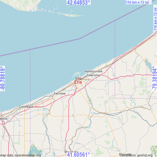
Erie GPS coordinates[2]
42° 7' 45.192" North, 80° 5' 6.216" West
| Map corner | latitude | longitude |
|---|---|---|
| Upper-left | 42.64853°, | -80.78819° |
| Center: | 42.12922°, | -80.08506° |
| Lower-right: | 41.60561°, | -79.38194° |
| Map W x H: | 116×116 km | = 72.1×72.1mi |
| max Lat: | 71.29058° ⇑23.2% North |
| Erie: | 42.12922° |
| min Lat: | ⇓76.8% South 19.06759° |
| min Long | Erie | max Long |
| -171.73463° | -80.08506° | -66.98998° |
| W 72.9%⇐ | ⇒27.1% E |
Elevation
Elevation of Erie is 201 m = 659 ft, and this is 93.8 m = 308 ft below average elevation for this country.
| Max E: |
3189 m = 10463 ft | 49.3% |
| Avg. | 294.8 m = 967 ft | |
| Erie | 201 m = 659 ft | |
Min E: |
-60 m = -197 ft | 50.7% |
See also: Erie elevation on elevation.city.
Geographical zone
Erie is located in North temperate zone (between Tropic of Cancer and the Arctic Circle). Distance of this Northern Tropic circle is 2078.4 km =1291.5 mi to South.| Distance of | km | miles | from Erie |
|---|---|---|---|
| North Pole | 5322.7 | 3307.4 | to North |
| Arctic Circle | 2716.8 | 1688.1 | to North |
| Tropic Cancer | 2078.4 | 1291.5 | to South |
| Equator | 4684.3 | 2910.7 | to South |


Nearby cities:
15 places around Erie: (largest is in red/bold)
• Albion
35.3 km =21.9 mi,  221°
221°
• Avonia
17.9 km =11.1 mi,  238°
238°
• Cambridge Springs
36.3 km =22.6 mi,  176°
176°
• Cranesville
32.8 km =20.4 mi, 220°
• Edinboro
28.6 km =17.8 mi,  187°
187°
• Fairview
17.8 km =11.1 mi,  232°
232°
• Girard
24 km =14.9 mi, 233°
• Lake City
25 km =15.5 mi, 239°
• Lawrence Park
5.7 km =3.5 mi,  63°
63°
• North East
22.8 km =14.2 mi,  65°
65°
• Northwest Harborcreek
7.8 km =4.8 mi, 73°
• Ripley
34.4 km =21.4 mi, 63°
• Union City
32.3 km =20.1 mi,  142°
142°
• Waterford
22.3 km =13.9 mi,  158°
158°
• Wesleyville
5.9 km =3.7 mi,  77°
77°
Sources, notices
• [Note1] Compared only with cities in United States existing in our database
• [Src1] Map data: © OpenStreetMap contributors (CC-BY-SA)
• [Src2] Other city data from geonames.org with taken over terms of usage.
• [Src3] Geographical zone / Annual Mean Temperature by Robert A. Rohde @ Wikipedia
